BLACK'S GUIDE TO GLASGOW AND THE CLYDE
Edited by G. E. MITTON
With five full-page illustrations and seven maps and plans.
LONDON.
Adam and Charles Black
1907
MAPS AND PLANS
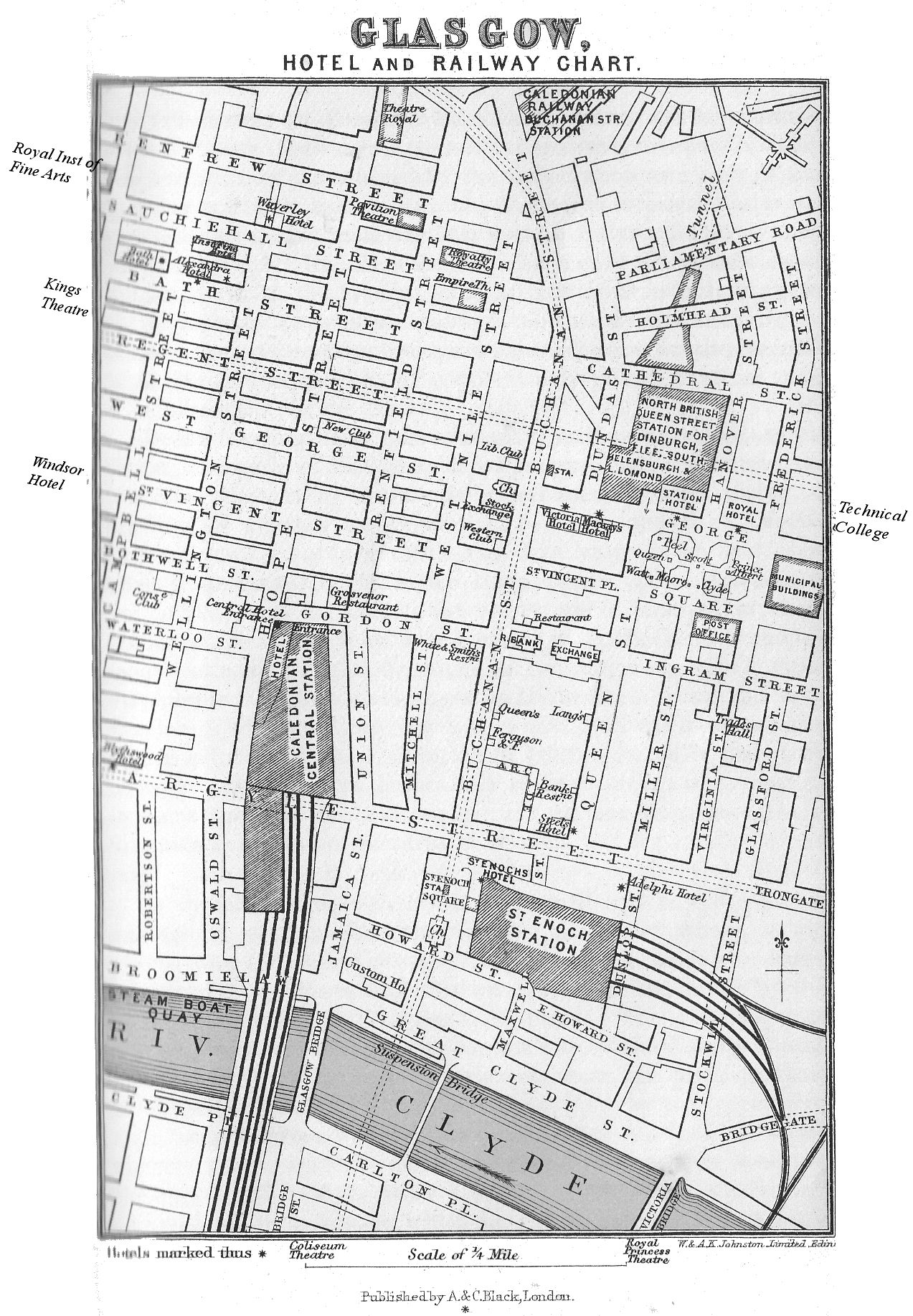
Glasgow, Railway Chart
Glasgow, Cathedral, Plan of
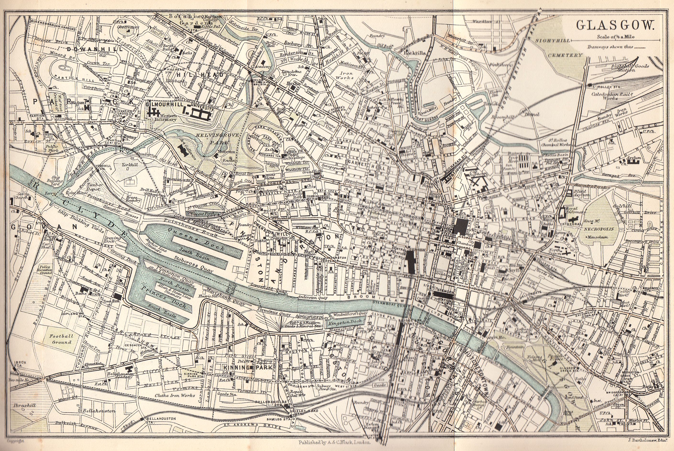
Glasgow, Plan of
Lanark and the Falls of Clyde
Arran and the Lower Clyde
Greenock, Plan of
Glasgow, the Clyde, Kyles of Bute, etc.
ILLUSTRATIONS
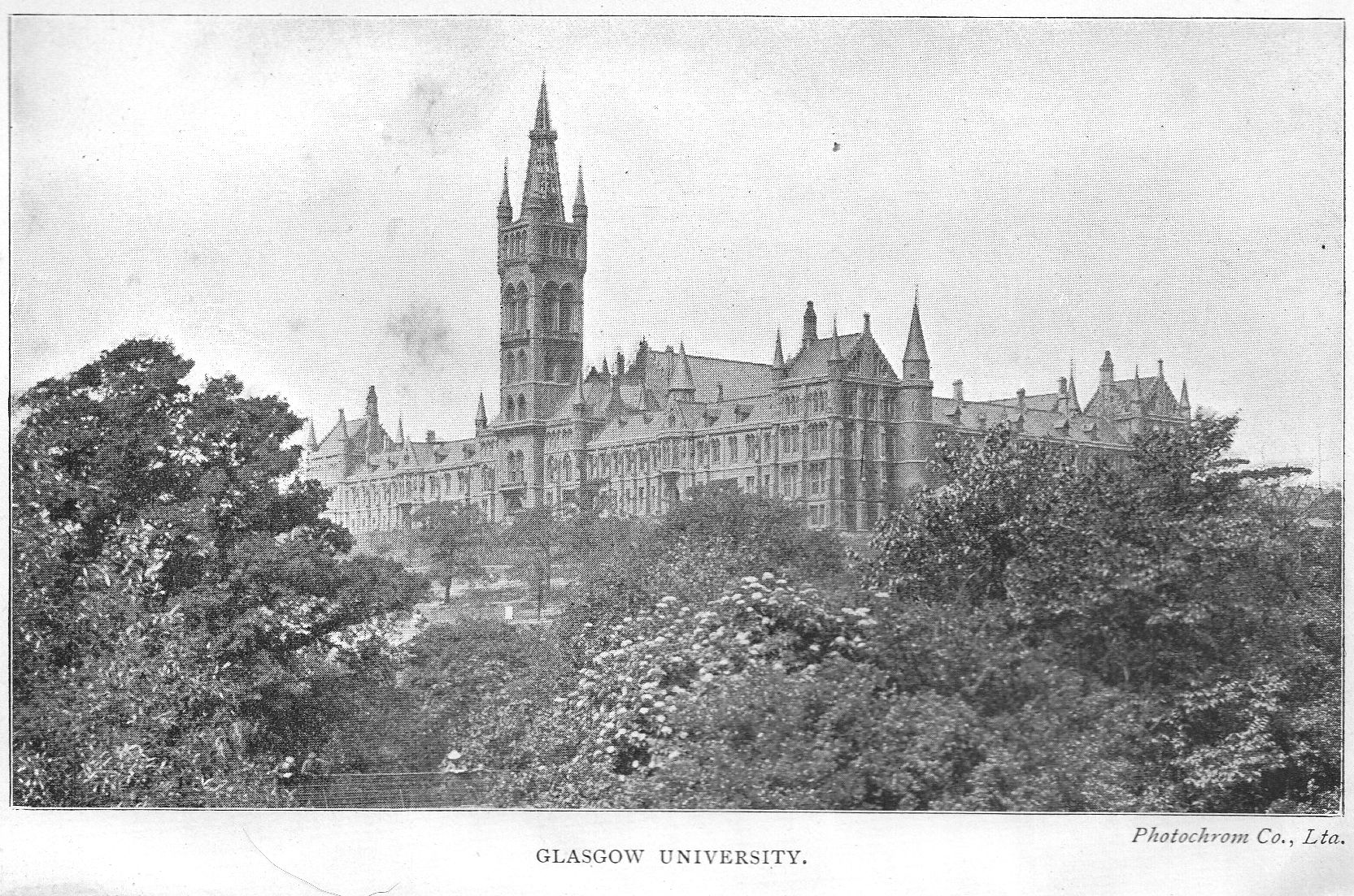
Glasgow University
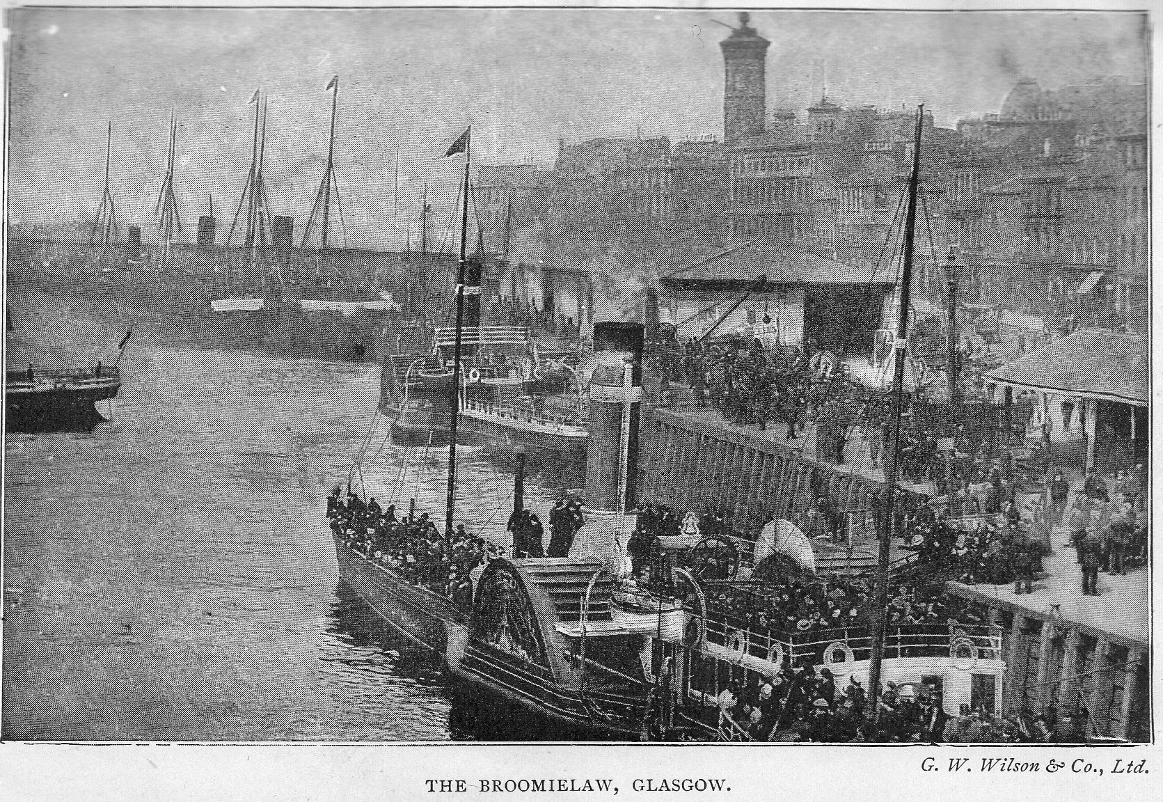
The Broomielaw
Falls of Clyde, Corra Linn
Burns's Cottage, Ayr
Arran: Brodick and Goatfell
GLASGOW
Principal Hotels. At Railway Stations - CENTRAL (Cal.), Gordon Street; ST. ENOCH (G. & S. W.), St. Enoch Square; NORTH BRITISH, George Square; Family Hotel, * WINDSOR (C), 250 St. Vincent Street; Others - Alexandra, 148 Bath Street; Bath (C), 152 Bath Street; Cockburn (Temperance), 141 Bath Street; Grand, 560 Sauchiehall Street; Royal, 50 George Square; Victoria, 19 W. George Street; Waverley (Temperance), 172 Sauchiehall Street.
Principal Commercial Hotels. Adelphi, Dunlop Street; Steele's, 5 Queen Street, corner of Argyle Street; Blythswood, 320 Argyle Street; George, Buchanan Street; Mackay's, W. George Street.
Restaurants and Dining Rooms. Ferguson and Forrester, 36 Buchanan Street; Queen's, 70 Buchanan Street; Lang's, 73 Queen Street (stand-up luncheon, sandwiches, etc.); White's, 7 Gordon Street;. Scott's, 90-98 Queen Street; Brown's, 79 St. Vincent Street; Grosvenor (New), Gordon Street, opposite Caledonian Station; Corn Exchange, 84 Gordon Street; City Commercial, 54-60 Union Street (Temperance); North British Hotel; Skinner's, Charing Cross. Several first-class Tea-rooms, Cranston's, etc., in Queen Street, Buchanan Street, Renfield Street; Miss Cranston's, Ingram, Argyle, Buchanan, and Sauchiehall Streets.
Post Office, George Square. Open from 6 A.M. to 11.45 P.M.; Sats. 10 P.M. Sundays, 8 A.M. to 9 A.M. Last Desp. S., 10 P.M.
Telegraph Office (in George Square), open at all times.
Returned Letter Branch and Postal Inquiry Office open from 10 a.m. to 4 P.M.
Railway Stations. Central -(Caledonian), for Carlisle and South (per London & N. W. Ry.), Bothwell, Hamilton, Edinburgh, Paisley, Gourock, Wemyss Bay, Ardrossan, and Kilmarnock. Also Low-Level for Dumbarton, Balloch, etc.
Buchanan Street -(Caledonian), for Stirling, Oban and West Highlands, Perth, Dundee, Aberdeen, and the North.
St. Enoch -(Glasgow and South-Western), for Carlisle and South (per Midland Railway), Kilmarnock, Dumfries, Paisley, Greenock, Ardrossan, Ayr, and Stranraer; also City Union Stations.
Queen Street - North British - (High Level), for Edinburgh, Fife, Dundee, Perth, Aberdeen, the South by East Coast, Fort-William (West Highland), etc.; (Low Level), Dumbarton, Helensburgh, Balloch (for Loch Lomond), to West; - and Coatbridge, Airdrie, Bathgate, Bothwell, Hamilton, to East.
Steamers. - Steamboat Quay and Broomielaw, for all the piers on the Firth of Clyde, also Millport, Arran, Ardrishaig, Oban, Fort-William, Belfast, Londonderry, Dublin, Liverpool. Passengers generally join steamers at Greenock, Gourock, or Craigendoran (Helensburgh), avoiding the upper reaches of the river.
Small Ferry Steamers constantly ply across the river in several places.
Tramways in every direction at minimum fare of half-penny. The principal cars run every few minutes at fares averaging Id. per mile. The chief point of inter-section is at junction of Jamaica Street and Argyle Street, whence every extremity of the city may be reached.
Omnibuses ply on various routes not served by Tramways, and connect with all suburban villages.
Subway. A circular line, serving the purpose of the London "Underground," but worked on the cable system, is carried underneath Glasgow, with stations at various points (St. Enoch Square, the most central), and is of much use. On Sundays the Subway trains do not begin to run till noon.
Places of Interest and Entertainment.
ART - See PICTURE GALLERIES.
BOTANIC GARDENS, with CONSERVATORIES, Great Western Road, Hillhead: free; see p. 316.
CATHEDRAL, top of High Street - free.
CEMETERIES - Necropolis, beside the Cathedral; Janefleld, Great Eastern Road; Sighthill, North of St. Rollox; Southern Necropolis, Caledonia Road; Craigton, Paisley Road; Sandymount, Shettleston; Dalbeth, east end of London Road; Cathcart, New Cathcart; Western Necropolis, Maryhill.
CITY CHAMBERS, George Square; County Buildings and Sheriff-Court, Wilson Street.
CREMATORIUM, within Western Necropolis, Maryhill.
COURT HOUSES, foot of Saltmarket.
EXCHANGES - Royal, Queen Street; Stock, Buchanan Street; Corn, Hope Street.
FOSSIL GROVE, in Whiteinch Park, west of Partick.
INFIRMARIES - Royal, close to the Cathedral; Western, Gilmorehill, near the University; Victoria, Queen's Park; and several others.
LIBRARIES - University, with Hunterian Collection; Mitchell, 23 Miller Street; hours 9.30 A.M. till 10 P.M. - Free. Stirling's, 48 Miller Street;; hours 10 A.M. till 10 P.M. - Free. for Consultation. Mechanics', 38 Bath Street. Athenaeum, St. George's Place. Philosophical Society, 207 Bath Street. Physicians', 242 St. Vincent Street. Procurators', 62 St. George's Place. Baillie's, West Regent Street. Also nine Public District Libraries.
MILITARY BARRACKS-Maryhill.
MUSEUMS - Hunterian, University, Gilmorehill. OBSERVATORY, ETC. - Victoria Circus, Dowanhill.
Music HALLS - Empire; Palace; Coliseum, etc.
PARKS - Kelvingrove, west end of Sauchiehall Street; Queen's, Victoria Road, south side; Alexandra, off Duke Street; Green, east from Cross; Cathkin Braes, near Rutherglen, etc.
PICTURE GALLERIES - Art Gallery and Museum. Branches at Glasgow Green (in People's Palace and Winter Garden), and at Camphill. Institute of Fine Arts, 175 Sauchiehall Street.
THEATRES - King's, Bath Street; Royal, 77 Cowcaddens; Royalty, 70 Sauchiehall Street; Grand, 190 Cowcaddens; Royal Princess, Main Street, Gorbals; Metropole, Stock well Street. CIRCUS - Sauchiehall Street. Lyceum Theatre, Govan, etc.
UNIVERSITY - Gilmorehill, Kelvingrove Park.
ZOO – HIPPODROME - New City Road.
GLASGOW, the second city in Great Britain, is not apt at first to inspire any great admiration in visitors, and the reason is obvious; the city is strictly utilitarian, and all the inevitable attendant drawbacks of manufacture, the noise, the dirt, the smoke, are very apparent. It is not until these things are disregarded that the real wonder of this great hive of commerce, its enterprise, its energy, and its administration can be appreciated. The streets are full of men and women eager to work, hurrying to and fro; electric tramcars laden with passengers pass every few seconds; looking down from the railway bridge to the Broomielaw, as the harbour is called, numbers of steamers are ever arriving and departing, and men, swarming like ants, load and unload. The history of the city, which is given below, is a romance of commerce; enormous has been the growth in a comparatively few generations. The town is really in Lanarkshire, but has largely overflowed into both Renfrewshire and Dumbartonshire. It is very hilly, and at the west end the streets are often mere terraces connected by short streets as steep as house-roofs. The spurs of the Scottish Highlands come within a few miles, reaching the shores of the Clyde as the Kilpatrick Hills at Old Kilpatrick, 10 miles below the town, and thence passing in a north-easterly direction as the Campsie Hills. These ranges bound the horizon to the north-west and north of the city; but, catching the moisture-laden breezes from the western sea, they cause a considerable precipitation of rain in their neighbourhood, and thus the rainfall of Glasgow reaches the high annual average of 45 inches.
History and Population. - All the magnificent growth and development of Glasgow has taken place within the last two centuries. It was not until 1690 that a charter was granted to the city creating it a royal burgh; before that time it had been an ecclesiastical town, a burgh of barony under the Bishop. Rutherglen, now a mere suburb, was a royal burgh long before its neighbour, and is in fact the only burgh that owns a charter granted by King David (d. 1153). But Glasgow is not lacking in early records, for about the middle of the 3rd century a Christian missionary, St. Ninian, established himself in a cell on the banks of the Molendinar at Glasgow; and after he departed the place was left to heathendom until the sixth century, when the patron saint, Kentigern, familiarly known as Mungo, settled by the river, and began his missionary efforts (see p. 306). It is not till 1116 that Glasgow again emerges into light, with the reconstitution of its Bishopric. In 1176 Bishop Joceline held office, and his efforts on behalf of the town were so zealous that he may almost be spoken of as the real founder of Glasgow. For his labours in regard to the cathedral see p. 307; but he did not confine himself to that only, he obtained from William the Lion the grant of a burgh with a weekly market, and later an annual fair, which from 1190 has been held unbrokenly to the present day. It begins on the Thursday of the second week in July and lasts a fortnight.
In the time of Mungo the place now known as Glasgow is mentioned as Cathures; when and why the later name arose is not known. It is of Celtic derivation, and among other suggested meanings that of "the grey smith," "the grey hound," "the dark glen," and "the dear family" may be noted. Of these the first, with its suggestions of hard work amid a pall of smoke, is certainly the most suitable at the present time, however different the conditions may have been in the far past.
Glasgow has been the theatre for several actions in the great drama of her country's history; Sir William Wallace overcame an English garrison in the streets. He routed his foes so that they fled to Bothwell, there to re-form and wait for reinforcements. Queen Mary was several times in Glasgow, notably when she visited her sick husband in order to decoy him to his doom (see p. 304). Her last engagement was fought at Langside, a battle, which though merely a skirmish in itself, decided the fate of the kingdom (see p. 318). During the Covenanting wars Glasgow played an active part, being in the centre of events. It was occupied by Claverhouse after his defeat at Drumclog. In 1679 Prince Charlie and tattered remnants of his disheartened army passed through the town in his retreat from England, when his hopes were at zero. The Prince held a review on Glasgow Green before resuming his march to the north. But these scenes are small in comparison with the great story of trade development.
Strange as it may seem, it was the discovery of America which gave Glasgow the first impetus on her successful career. Her position enabled her to take advantage of the new opening. Tobacco and sugar became her staple imports, and by the outbreak of the War of Independence she controlled half the tobacco trade of the kingdom. It was also after the discovery of America that she found herself in a new position, being one of the most important of the ports of embarkation for the new land. The Union with England may be noted as the second of the changes which sent up her trade records by leaps and bounds. To quote from the able preface in The Handbook on the Municipal Enterprises:-
"At that time the population was not more than 13,000. ... In 1740 it numbered 17,000, forty years later it was 43,000; the first official census of the United Kingdom in 1801 gave the population as 83,769. One hundred years later, in 1901, the population within the limits of the municipality was returned at 760,423, but, adding to that the inhabitants of Govan, Partick, and Kinning Park, which, though under distinct municipal control, are parts of the city, the total amounts to 904,948. Allowing for the growth of the city since 1901, and taking into account suburban population not under municipal authority, the inhabitants of Glasgow at this day certainly exceed 1,000,000."
The municipal motto quoted briefly as "Let Glasgow flourish" has no doubt sometimes jarred on those who see in it only egotism, but the whole sentence, "Lord, let Glasgow flourish by the preaching of Thy Word," conveys an entirely different impression. The armorial bearings of the city contain a tree, a bird, and a fish with a ring in its mouth, commemorating three of the most notable miracles wrought by St. Kentigern.
Thu city, no doubt, owes much to its position and resources, but still more to the courage and energy which has been a characteristic of its sons. Its site has already been briefly noted. The river formed a highway for trade, but in early days there lay a long stretch between the city and the limit of incoming sea vessels; in fact, there were about fifteen miles of sand-banks and shoals, obstacles which required millions of money for their removal. Attempts to clear the obstruction were made in the 16th and 17th centuries, and in the latter a port and harbour were established at Port Glasgow; but this was a failure from the first. In 1759 an Act of Parliament for cleansing and deepening the channel was obtained, and ever since the work has been continued at a total cost to the Clyde Navigation Trustees of something like eight millions.
This enterprise answered in an unlooked-for direction; besides the great increase of already established trade, a new branch was opened, that of shipbuilding, in which Glasgow has ever since been pre-eminent, not in Britain only, but in the world. The launch by Henry Bell of the "Comet" of three-horse power, the first European steamboat in 1812, inaugurated the vast industry, and the record was reached in 1902 when 312 vessels of 516,977 tons and 458,870 horse power were launched in in the aggregate from the many mighty yards. It is a scene one never can forget if one comes up the river in the busy time of day, or as the wintering light turns grime to gold - the activity of myriads of men creating mighty engines to traverse all parts of the world, with the clang of tens of thousands of busy hammers (see p. 317).
But second only to the river as a factor in the prosperity of the city is the situation, which is actually upon a great coal-field with its correlative iron; this puts into the hands of her manufacturers two of the indispensible requisites for their work. The coal-fields of Lanarkshire are the richest in the world, and the yearly output now amounts to 17,000,000 tons. In 1828 Neilson's hot blast iron furnaces first came into use, being tried at the Clyde iron-works; the remarkable economy thereby effected developed the iron industry of Scotland at a rate which long distanced all competition. Glasgow is exceptional in having blast furnaces actually within her municipal bounds. Great forges with powerful steam hammers and other appliances, pipe-founding works, and malleable-tube works, boiler-making, locomotive engine building, sugar machinery, sewing machines, and general engineering are among others of the most important industrial enterprises of the city.
Bleaching and calico printing were established in Glasgow earlier than in Lancashire; and these industries still prosper. In fact, here chlorine was used for bleaching before it was introduced into any other British locality, and its introduction was due to the advice and information James Watt communicated to his father-in-law. In Glasgow, also, bleaching powder (chloride of lime) was discovered by Mr. Charles Tennant, who thereby laid the foundation, not only of the gigantic St. Rollox chemical works, but gave the first impetus to the chemical industries generally. From remote times hand-loom weaving was the principal occupation in many rural villages around Glasgow; and with the steam-engine discoveries of Watt, and the inventions of Arkwright, Hargreaves, Cartwright, and others, the textile industries came to be centred in great factories, and these, for now a century past, form one of the leading industries of the city.
Among a host of her sons distinguished for mechanical invention we may mention also the names of Joseph Black and Lord Kelvin.
Perhaps no city in the world owes so much to its municipal government as Glasgow, and this fact is worthily typified by the City Chambers, which can only be described as magnificent (see p. 302). The Municipal Corporation supplies the city with gas, electric light, and water; it owns the tramways, markets, parks, galleries, baths, and washhouses, etc., and has a telephone system of its own. Perhaps the most important of all the municipal activities was that of 1855, when the Corporation acquired the right to bring a plentiful supply of good water from Loch Katrine; and this was supplemented by a second line of aqueduct in 1885. These aqueducts are about 23 and 25 miles in length, and are capable of discharging 110,000,000 of gallons of water per day into the service reservoirs. In order that the water of the loch might be kept free from pollution, the feuing rights over the whole drainage area of Lochs Katrine and Arklet were, in 1892, acquired by the Corporation at a cost of £17,000.
There are few relics left of ancient Glasgow, and the growth of modern times has obliterated any traces of the early city. In the year 1866 an Improvement Act was obtained by the city, the operations under which have served as models for all other great commercial towns. The works have been carried out at a cost of over £2,000,000, but by the realisation of the property in the possession of the Trust, the total cost to ratepayers has only been £568,386. Many streets have been entirely reformed; and in others dens of squalor have been swept away. Model dwellings and "family homes," suitable for the poorest classes, have been constructed, and the Alexandra Park has been formed. Excellent sanitary supervision and an unequalled water supply being maintained, Glasgow has now become one of the healthiest cities in the kingdom.
Three large terminal Railway Stations bring traffic to the heart of the town, respectively serving the three great Scottish Companies - the Caledonian, North British, and Glasgow and South-Western. By means of these railways and their local branches, as well as by the magnificent fleet of river steamers, travelling facilities to and from the city in all directions are very great. From the Alexandra Park, on the north-east, to Pollokshields, south-west, the City Union Railway traverses the town, and connects the North British Bathgate line with St. Enoch station and the South-Western system. Two underground railways, belonging to the North British and Caledonian Railway Companies respectively, have their chief stations beneath the high-level termini of those companies, and form connections with the suburbs; also with Dumbarton, Helensburgh, and Loch Lomond to the west, and Hamilton to the south-east. A circular cable subway has its principal station in St. Enoch Square, whence it proceeds round by Kelvin Bridge, Partick, and Govan. Within the city electric trams traverse almost every important thoroughfare, and run into the suburbs.
As has been said, Glasgow is not a city that particularly impresses a visitor at first sight, nevertheless there are several things which a visitor ought certainly to see, among which may be mentioned The Cathedral, the Art Gallery and Museum, The City Chambers, and the Botanic Gardens, not to mention smaller things. The plan we have chosen is that of giving an account of each of these objects as we come across it in a general survey of the city itself.
It may first be premised, however, that Glasgow is an expensive place to stay in, the hotels at the great railway stations have vied with each other in becoming more and more magnificent, and charge accordingly; as they have unlimited custom they have no need to condescend to those whose purses are not well stocked.
George Square is in many senses the real centre of the city and here we may start our general account. On its north side in the principal station of the North British Railway. The western side is occupied by the Merchants' House and the Bank of Scotland. On the south side the principal building is the Central Post-Office. The whole of the eastern side is occupied by the City Chambers. (See below.) The Square is wide and open. Seats, which are generally fully occupied, are placed about at intervals in the central space, the middle of which is occupied by the Scott monument, which, if not so striking as that at Edinburgh, has the merit of having been the first erected to Scott in his native land. It consists of a fluted column 80 ft. high, surmounted with a colossal statue. Flanking it, on east and west, are equestrian bronze statues of Queen Victoria and the Prince Consort, of no great artistic merit. There are also, round the Square, figures of James Watt, by Chantrey; Sir John Moore (a native of Glasgow), by Flaxman; Lord Clyde (also a native), by Foley; Dr. Thomas Graham, formerly Master of the Mint, by W. Brodie, R.S.A.; James Oswald, M.P.; Dr. David Livingstone the traveller, Thomas Campbell the poet, and Sir Robert Peel, all by John Mossman; Robert Burns, by George E. Ewing; and Rt. Hon. W. E. Gladstone, M.P., near the City Chambers, unveiled by Lord Rosebery in 1902, and designed by Hamo Thorneycroft.
City Chambers
City Chambers. Glasgow has grown so fast that four times within a century have the municipal offices required enlargement. In 1810 the offices were removed from the ancient Tolbooth to the buildings facing the Green, now used as a Justiciary Court. Thence, in 1842, they were transferred to new buildings in Wilson Street, now occupied as a Sheriff-Court and County offices; and, in 1875, they were moved to Ingram Street, where a building was erected forming one block with the Sheriff-Courts, etc. Within a very few years this increased accommodation was found to be quite inadequate, and now a building which easily takes a foremost place among its kind all over the world has been erected. The designs were by William Young of London (a native of Paisley); and the whole building is in the Venetian Renaissance style. The Council Chamber is placed over the grand entrance, facing George Square; and the Banqueting Hall, with suite of reception-rooms, occupies the George Street frontage. The centre and wings of the principal elevation to George Square project and rise an additional story, the centre being capped with a pediment flanked by two domed towers, and the wings end in domes and lanterns. In the centre, over the entrance loggia, a tower rises about 100 ft. above the main parapet - in all more than 200 ft. from the street level. The building is enriched by statuary groups and figures (Geo. Lawson, H.R.S.A., and others). But splendid as is the exterior, the interior will strike a stranger with even greater admiration. The employment of alabaster, marble, and coloured tiles in the principal staircases, halls, and corridors produces an effect of magnificence not easily to be surpassed. The entire cost of the pile, including £170,000 for the site, exceeded £500,000.
George Square lies in the very heart of the city, and close to it are the principal places and most important streets. The three great railways have already been noted. Queen Street Station, the terminus of the N. B. R., is on the north side of the Square. The principal stations of the other two are St. Enoch's (G. & S.W.) at the foot of Buchanan Street, and the Central (Caledonian) in Gordon Street. Nearly all the streets here lie at right angles.
At one time St. Enoch Square was a rural churchyard with a church dedicated to St. Tanew, the mother of Kentigern, a name which, by a strange corruption, became Enoch.
The streets running north and south are well supplied with excellent shops, of them all perhaps Buchanan Street is the most important. In it are the fine offices of the Glasgow Herald. An arcade filled with shops leads off from the eastern side near the south end.
In Queen Street (east) is the Royal Exchange, and in Ingram Street is Hutcheson's Hospital, which corresponds in some ways with Heriot's Hospital in Edinburgh.
In Miller Street is the Mitchell Library, which is Glasgow's public library. It originated in a bequest by Stephen Mitchell, a native of Linlithgow, who carried on a tobacco manufacturing business in Glasgow, and died 1874. The amount he left for this purpose was close on £67,000. Many bequests to the library have since been made, of which the most important is that of Robert Jeffrey, of over 4000 volumes, some of them works of great rarity and value. The library now contains over 180,000 volumes and has outgrown its space. A new building is to be erected between St. Andrew's Halls and North Street. There are branch libraries in connection in almost every suburb; to the erection of these Mr. Carnegie has contributed £100,000. In Miller Street is also Stirling's Library, and Baillie's Library is in West Regent Street; both open to all comers for reference. Near the foot of Glassford Street (made later) once stood Shawfield House, belonging to Campbell of Shawfield, who, with the compensation received for the damage done to it in the Malt Tax riots of 1725, bought Islay. Twenty years later Prince Charlie stayed here and met Clementina Wulkinshaw, by whom his life was to be so deeply influenced. It was bought in 1760 by John Glassford, one of the "Tobacco lords," who strutted about in his scarlet cloak and curled wig, with his cocked hat and gold-headed cane, as gay as any courtier. 1t was after him the street was named.
Passing farther eastward, we come to High Street, running roughly north and south, and traversing the older part of the town. At its intersection with the Trongate stood the old Cross of Glasgow, once the centre of the city. This part has been much altered by modern improvements, and nearly all the old houses - in many cases, it must be confessed, very insanitary and squalid even if picturesque - have been swept away. At the north-west corner of the two intersecting streets stood the ancient Tolbooth or prison, five stories high and turreted. It will be remembered that it was here young Osbaldistone visited his friend in distress; during which visit he discovered to his astonishment that his mysterious guide was none less than Rob Roy the redoubtable cattle-stealer himself (Rob Roy). The contiguous building in the Trongate is now all that remains of the old town hall, and it is cut up into shops. When Defoe visited Glasgow in 1726 there were colonnades or piazzas in front of the houses of the four streets radiating from the Cross; these called forth his praise, in spite of the meanness of the small shops they sheltered and darkened. It was in "Donald's Land," on the north side of the Trongate, that Sir John Moore was born.
In the middle of the street is a equestrian statue of William III. presented to the burgh in 1735 by James Macrae, Governor of Madras. Near it is one of the accesses to the underground line of the Caledonian Railway. On the south side of the street projects the Tron Steeple, a venerable but stunted spire, dating from 1637. This forms an arch over the pavement. We are now in the centre of old Glasgow, though little enough remains of it. To the north is the High Street mentioned below. An ancient street called Drygate originally led from the Cross, and in the upper part of it was the house in which Darnley lay sick when Queen Mary came to seek him, to condole with him, and to lure him with all her charms, until he consented to be carried forth in a litter to journey with her to Edinburgh, where he was to meet his awful fate. Eastwards is the old Gallowgate, and southwards the Saltmarket, for ever associated with Bailie Nicol Jarvie. The name arose from the fact that the salt for pickling the salmon caught in the river was sold here. The south end is called Jail Square, and here was formerly the place of public execution. The Court-House, as we have said, served for a time as the Municipal offices. The whole of the Saltmarket is modernised.
Off the Saltmarket runs the Briggate, a once fashionable and busy street, which led to the ancient bridge of the city. Notwithstanding its intersection by railways, the Briggate is one of the few streets in Glasgow which still wears a 17th-century aspect. Near its farther extremity there yet remains the Briggate Steeple, now maintained by the Corporation as a relic of the Merchants' House, built in 1659 by Sir William Bruce of Kinross, the architect of the more modern part of Holyrood Palace. In the words of McUre, the Glasgow historian, "the steeple is of height 164 foot, the foundation is 20 foot square: it hath three battlements of curious architecture above one another, and a curious clock of molton brass, the spire whereof [of the steeple] is mounted with a ship of copper finely gilded in place of a weather-cock."
Before leaving this part we may just mention Glasgow Green, the park of the people. The park has a frontage on the river of about 1and-a-quarter miles. It is perhaps the worst placed of all Glasgow's parks for vegetation, being in the thick of the drifting smoke, but nevertheless of late years much has been done to improve it. The two little streams, the Molendinar (see p. 297) and the Camlachie, ran across it, and when these became mere sewers they were covered in. The Nelson monument was put up in 1805, and is as much a rendezvous for the discontented ranters of Glasgow as Hyde Park is for those of London. The Doulton fountain, which was exhibited at the Glasgow International Exhibition of 1888, is a really fine piece of work. The People's Palace and Winter Garden, were opened by Lord Rosebery in 1898, and in the former there is often a fine loan collection of pictures to be seen.
If we follow the High Street northwards, we pass the prison and ascend what is called the
For over four hundred years the University was in the High Street; the site may be identified by the present College Station. Many are the footsteps of men who have become famous that we might hear if we listened to the echoes of history; among them we must mention one, a native of Glasgow by birth, Thomas Campbell the poet, b. 1777, tenth child of his father, who at the early age of thirteen printed and sold to his fellow-scholars verses of his own composition. He was later Bursar and then Rector of the University. In the old building of the University worked also Smollett, Lockhart, "Christopher North," and Tait, afterwards Archbishop of Canterbury. The College stood partly on the site of the old Monastery of Blackfriars.
Soon after we come to a striking group formed by the cathedral backed up by the rising ground of the Necropolis.
The Cathedral
Admittance daily 10 A.M. till dusk or (in summer) 6 P.M. No gratuities. Service on Sundays 11 A.M. and 2 P.M.
The Cathedral has the distinction of being the only old minster in Scotland besides that at Kirkwall which is still in good preservation. At first sight it is rather disappointing, being of no great size, and with a smoke-blackened exterior, and rather ungraceful spire; but after visiting the interior, and especially the crypt, its great charm - the charm which venerable age and good workmanship must always produce - will be felt.
Sir Walter Scott, by the mouth of young Osbaldistone in Rob Roy, doubtless spoke his own opinion of it in the following words:- "The pile is of a gloomy and massive rather than an elegant style of Gothic architecture; but its peculiar character is so strongly preserved, and so well suited with the accompaniments that surround it, that the impression of the first view was awful and solemn in the extreme. ... We feel that its appearance is heavy, yet that the effect produced would be destroyed were it lighter or more ornamental."
The Cathedral is dedicated to St. Kentigern (p. 297), who came from the Orkneys on his missionary errand to the district of Glasgow, then called Cathures, about 539; he was subsequently expelled by the king or chieftain, and took refuge in Wales, where he founded the See of St. Asaph. He was recalled by the successor of his persecutor, and about 560 erected the earliest church on the site of the present Cathedral. He is said to have died in 603, and was buried at the east end of the ground on which the Cathedral stands. For more than five centuries nothing further is heard of the church in Glasgow. It was probably of wood, and possibly fell to pieces gradually, though it is likely that many pilgrims were attracted by the shrine of so great a saint. King David, whose mother was St. Margaret, came to the throne of Scotland in 1124, having previously held the Lowlands as Earl. He founded the See of Glasgow, made his tutor, John Achaius, bishop, and endowed the first cathedral, dedicated 1136, which was built on the site of St. Kentigern's church. Of this cathedral there remains nothing. Succeeding bishops added and restored, and the earlier part of the existing building may be attributed to Bishop Ingelram (1164). A mere fragment of this remains, and may "be found about twenty feet from the west end of the interior of the south aisle of the present lower church," and consists of nothing more than "a foot or two of splayed bench table, a single wall shaft of keel section, with its unfinished octagonal capital, and its base with large square plinth, and a few stones of walling" (P. Macgregor Chalmers). Bishop Joceline began adding to his predecessor's church, which, while he was actively engaged in repairing it, was partially burnt. Of his rebuilding a considerable part remains, including the south aisle, and the north wall of the north aisle of the lower church, but the bishop died before the completion of his great scheme, and it was not until the time of Bishop Bondington (1233) that Joceline's unfinished choir was removed and replaced by the present one. It was Bishop Robert Wishart (1272) who took the nave in hand, and it is to Bishop William Lauder (1408) that we owe the design of the beautiful Chapter-Rouse. Bishop John Cameron (1426) practically completed the work; he finished the Chapter-House and built the spire of the cathedral. He also made a Consistory House and Library which stood at the south-west angle, and were completely destroyed in 1846.
Having in this very brief and summary sketch indicated something of the growth of the building, we may turn to it as it now stands.
The style is Early English, though differing greatly in one part and another. The absence of chairs or any kind of seats in the nave adds greatly to the effect, as the whole can be seen in one fine sweep. The arches in the aisle arcades are sharper than those in the choir, and the whole is characterised by a greater simplicity, though it must be remembered the nave is of the later date. Behind the plaster ceiling is the original wooden roof of oak, unfortunately hidden. There are clerestory and triforium to see, both worth notice. Looking up toward the choir the first impression is one of disappointment, for the rood-screen which separates the two is very heavy, and pierced only by a low door. It is but fair to add that this screen, due to Bishop Blacader (1484), has been greatly admired, and is in itself a fine piece of work, with a parapet of good tracery, but it is against present day ideas that such a cumbersome obstacle should break the vista of a beautiful cathedral.
The Choir itself is very grand. It is raised considerably above the nave, standing over the Lower Church. The chief feature, the moulding, is seen best on the capitals of the piers. One peculiarity is a chapel of four altars behind the high altar; this corresponds with the better-known Chapels of the Nine Altars at Durham; like that cathedral also Glasgow ends now squarely, but is conjectured to have once finished in the apsidal form. The choir is used for service and is called the High Church. In the north-east corner of the High Church is the entrance to the Sacristy.
Returning once more to the nave, we note that there are no real transepts, only the foundations or lower part of the southern transept, in itself a perfect little chapel. This used to be known as the Dripping Aisle from the perpetual dropping of water from the roof, a peculiarity which no longer continues. It shows that probably transepts were at one time contemplated in the plan of the building. But the chief feature of architectural interest is the Lower Church or Crypt, which has already been more than once referred to. It follows the general plan of the choir above. To the least knowing the design of the pillars must appear curious. The four in the centre form a square, indicating the position of St. Mungo's Shrine, which remained until the Reformation. The design of the vaulting and the carving on the bosses should be especially noted, but it is a drawback that it is often so dark as to be difficult to distinguish the features of interest. It was in this crypt that Scott placed one of the notable scenes of Rob Roy. In the south-east corner is St Mungo's Well, the traditional spot on which the first saint founded his church. At the east end is an old statue, popularly said to be St. Mungo's tomb, but in reality probably connected with the tomb of the famous Bishop Wishart. Edward Irving, founder of the Catholic Apostolic Church, is buried in the crypt, and there is a memorial window to him executed by Bertini of Milan.
In the north-east corner of the crypt, below the Sacristy, we find the beautiful 15th century Chapter-House, though the foundations are of a much earlier date. The doorway is well moulded, and the groined ceiling is supported by a slender shaft 20 feet in height. What is known as the Covenanters' Stone, recording the names of some who were killed in those disturbed times, is now to be seen here.
About the middle of the 19th century a general restoration of the Cathedral took place, when the ancient tower and Consistory House on the west face of the Cathedral were removed, an indiscretion which has been lamented more on antiquarian than on architectural grounds.
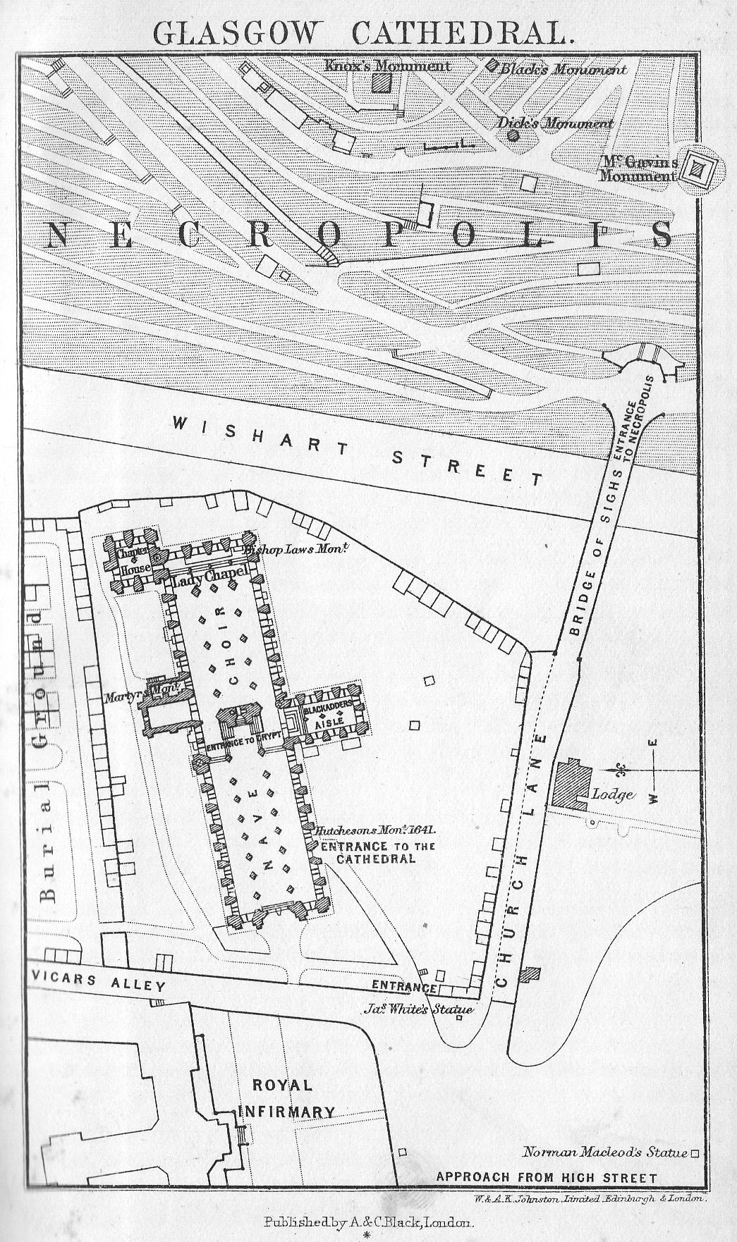
Cathedral Windows
It was also decided to fill in the windows with stained glass. The eastern window, one of the finest of the series, was presented by Government. The first window was erected in 1859, and the last in 1864, when the whole (81 in number) were formally handed over to the Crown. The windows in the nave, transepts, and Lady Chapel were all executed at Munich; those in the chapter-house and crypts by various British and foreign artists, whose names, as well as those of the donors, are given in the descriptive catalogue sold in the Cathedral. The subjects are arranged with a certain regard to chronological order, commencing at the north-west corner of the nave with the expulsion of Adam and Eve, and continued to the south-west angle with other Old Testament characters. The great west window contains subjects taken from the history of the Jews: and the north transept window figures of the prophets and John the Baptist. The subjects in the choir illustrate the parables; those in the Lady Chapel are figures of the apostles; and those in the great eastern window the evangelists. The clerestory windows are as yet only partially filled with stained glass.
The revenues of the See of Glasgow were at one time very considerable, as, beside the royalty and baronies of Glasgow, 18 baronies of land in various parts of the kingdom belonged to it. Parts of these revenues have fallen to the University of Glasgow and part to the Crown.
Among the line of Bishops there are many men of learning and dignity above the average; particularly noticeable is the name of Bishop Robert Wishart (1272), a firm friend of Wallace and Bruce, who furnished from his own wardrobe the robes in which Bruce was crowned. For this act he suffered imprisonment for some years at the hands of Edward I. The See of Glasgow was made Archiepiscopal in 1491 at the instance of James IV., who was an honorary canon of the Cathedral. Among the Archbishops the names of Bishop Burnet and Leighton stand out. During the fit of destructive enthusiasm which followed the Reformation the building was saved from injury by the zealous activity of the craftsmen of Glasgow, who forbade the fulfilment of an edict which had gone forth for the destruction of the "idolatrous monument." The structure was carefully repaired by certain of the Protestant Archbishops, notably by Bishop Law, whose monument may be seen in the Lady Chapel.
On the exterior of the cathedral the great tower and spire should be noted, and the gargoyles projecting from the parapet, especially those on the north side, which are in good preservation and very original.
The Bishop's Palace or castle, now vanished, stood a little S.W. of the cathedral, nearly in front of the present Royal Infirmary, the remains were removed in 1789 to make way for that building. The principal architectural feature of the Infirmary, which was designed by brothers Adam, and opened in 1794, is the central dome, which forms a roof to the lecture and operating theatre. In front of the building is a bronze statue of Sir James Lumsden, a former Lord Provost. To the north of the Infirmary are new buildings for the Medical School.
The Necropolis
From time immemorial this part has been associated with the burial of the dead. St. Ninian made a burying-ground, on the site of which now stands the Cathedral, for it was to this spot that the untamed oxen led the body of Fergus, thus deciding St. Kentigern here to fix his cell. Somewhat similar tales are told of many great cathedrals. The present Necropolis is on a steep conical hill rising from the valley of the little Molendinar stream, and with its trees and various monuments it forms a striking background to the Cathedral. Across the valley is a light bridge called the Bridge of Sighs, from the many sorrowful processions that have wended across it. The cemetery is the property of the Merchants' House, and was known at first as the Fir Park. In 1824 the tall column surmounted by a statue of John Knox was put up by public subscription, and only subsequently did the idea of making the place a public cemetery occur to any one. It cannot, of course, bear comparison with the well-known Tomnahurich cemetery at Inverness, but it is a noticeable spot. The column to John Knox stands up above its fellows, but there are other monuments also conspicuous, namely those to William Black, William McGavin, George Coventry, Rev. Dr. Heugh, Charles Tennant of St. Rollox, Principal Macfarlan, the poet Motherwell, Sheridan Knowles, and Edward Irving (see p. 308). In one corner of the Necropolis is the Jews' burying-ground, in which the first body was laid in 1832.
There is a good view of the city from the summit of the Necropolis, which rises to a height of 200 or 300 feet.
St. Rollox
Passing in a line with the High Street by the Royal Infirmary, northward through Castle Street (so named from the Bishop's Castle), the Monkland Canal is crossed, and the visitor at once finds himself in the grimiest of manufacturing regions. On the one hand are the great works of the Caledonian Railway Company. On the left hand, stretching along the canal bank, are the famous St. Rollox Chemical Works of Charles Tennant, Sons, and Company. The works are distinguished by the great chimney stalk, 435 ft. high, long the pride and boast of Glasgow, until an ambitious rival erected another a few feet higher, designed by the late Professor Macquorn Rankine. Then we pass the huge Sighthill cemetery.
Farther out still is Springburn with its public park, in which is a winter garden.
The Alexandra Park,
one of the numerous public pleasure-grounds within the city, is situated at the extreme east, and can be reached by tramway from George Square or Duke Street. It was acquired at a cost of £40,000 by the City Improvement Trust, and a considerable additional sum has been expended upon it.
If we return now to George Square we shall easily find our way westward by any of the great east and west running streets, of which the principal are Sauchiehall Street (such a stumbling block to southern tongues) on the north, and Argyle Street on the south. In Sauchiehall Street are the Royalty Theatre, Theatre Royal, and the Empire Palace; and in Berkeley Street, opening off it, are the St. Andrew's Halls, the property of the Corporation, where the orchestra can seat 650 performers. In Sauchiehall Street, too, is the Institute of Fine Arts, where periodical exhibitions of Modern Art take place. At Charing Cross stands the Grand Hotel, and from this point the residential west end of Glasgow may be said to begin.
Argyle Street, which continues all the way to Kelvin Bridge in one direction, and by Trongate and Gallowgate the other, runs roughly parallel to the course of the river for about five miles.
The great feature of the western end of the city is Kelvingrove Park.
Kelvingrove Park.
The Park owes much to its hilliness, for the abrupt rises and falls add greatly to its picturesqueness, and make it seem much larger than it is. From the flagstaff at the east end the splendid buildings of the University can be seen towering majestically on their high ground. Beyond them is the Western Infirmary; and some new buildings in connection with the University. Farther to the left is the handsome red sandstone building of the Fine Art Gallery and Museum.
In the middle distance is a fountain called the Stewart Fountain, well carried out, which serves as a rendezvous for old and young. It was designed in commemoration of Lord Provost Stewart, to whom the city owes its unequalled water supply. Between it and the Fine Art Gallery is the old Museum, whose contents are now transferred to the new one: it houses the Jeffrey Reference Library temporarily. In front of the Art Gallery are two exceptionally good bowling greens. The Park is 85 acres in extent, and was acquired by the Corporation in 1852. It is well laid out, and the flower beds add no small charm to it. It is traversed by the river Kelvin, which, it must be confessed, is a mere muddy brook. In the Park were held the two great International Exhibitions of 1888 and 1901.
The University
The University of Glasgow is second in seniority among Scottish Universities, having been founded by a charter of James III. of Scotland on the instance of Bishop Turnbull, and further confirmed by a Bull of Pope Nicholas V. in 1450.
It was at first established in a tenement in the old street named Rotten Row, not far from the Cathedral, thence in 1460 it was moved to the High Street, and there remained until 1870. At the Reformation it suffered as much as other institutions of its kind, and for some time subsequently lingered on in a very precarious state, but in 1577 it was remodelled. In 1846 an attempt was made to transfer it to a more worthy position, but nearly twenty years elapsed before the project was taken up in earnest. The present magnificent site and worthy buildings cost an enormous sum, which was made up in various ways, partly by the sale of the ancient site, partly by munificent subscription, and partly by the help of the National Exchequer, for Parliament granted no less than £120,000 in six annual instalments. The new buildings, erected on Gilmorehill, as the site is called, were designed by Sir G. Gilbert Scott; the foundation was laid by King Edward in 1868, and two years later they were first opened for classes. There are now thirty-one chairs, and over 2000 students. The eminent men connected with the University have been so many that it is quite impossible to attempt any exhaustive list: a few among the names, however, may be mentioned:- Adam Smith, James Watt, Sir William Hamilton, William Hunter, Edmund Burke, Francis Jeffrey, Thomas Campbell, Sir Robert Peel, Macaulay, the two Lyttons, Disraeli, Gladstone, John Bright; and among those of our own times, Lord Lister and Lord Kelvin.
From the terrace in front one can see the facade of the noble range of buildings with the great spire rising 300 feet from the ground. This was erected in 1888 as the result of a bequest. The latest additions to the University were opened in April 1907 by H.R.H. the Prince of Wales, and include the Natural Philosophy and Medical Departments, which cost £70,000.
Otherwise the chief points to note are the Common Hall of the University, known as the Bute Hall, which was the result of a donation of £45,000 from the late Marquess of Bute.
This is one of the most important architectural features of the buildings. It forms the central and main portion of a pile which intersects, from north to south, the great quadrangle, and binds together the various public departments, senate hall, library, reading-room, and museum of the college. The Bute Hall rises over a range of cloisters, and internally is of grand proportions. The fittings throughout are richly wrought in the Gothic style, and a magnificent Gothic screen at the south end separates this noble apartment from the smaller Randolph Hall, which connects with the Senate Hall, etc. At the north end the Grand Randolph Staircase supplies the principal entrance, and gives access also to the reading-room, Hunterian Museum, etc.; the cost of the Randolph Hall and staircase fell on the bequest to the University by Charles Randolph, shipbuilder; and the cloisters were partly erected by public subscription.
In the Museum (open free daily three days a week, 10 A.M. to 5 P.M., and other three days on payment of threepence; closes at 3 P.M. on Saturdays). Besides the usual Mineralogical and Geological details, there is an unrivalled collection of coins valued at £80,000; this, however, is not shown except on special occasions. There is a library attached to the Museum, part of the same bequest, and this contains a valuable series of Caxtons, Pynsons, and other early printed books, also a collection of MSS. the value of which is now only beginning to be realised.
The University Library (open 11 A.M. to 2.30 P.M. in winter, and 11.30 A.M. to 2 P.M. Monday, Wednesday, and Friday in summer) is on the ground floor, and is especially rich in Philosophical and Theological literature. Like every other public institution in Glasgow - surely the most liberal hearted of all cities - it has been enriched by numerous bequests of great value. Of these the two separate Euing bequests are the most remarkable, one consisting of more than 10,000 volumes, many of them of great rarity and value, and the other of a unique collection of Bibles. The library is open to others than those connected with the University on the modest payment of 10s. 6d. yearly.
In close proximity to the University is the Western Infirmary. The institution is largely used for clinical instruction in connection with the Medical School of the University. Adjoining the Infirmary is the Anderson's College Medical School.
Art Gallery and Museum
This Gallery is worthy of the high estimation in which it is held by the city; for it is a splendid building containing a valuable collection.
The origin of the collection is really due to Archibald McLellan, at one time a Town Councillor, who left his collection of valuable pictures to the city; but when it was discovered that his affairs would not in justice allow of such a bequest, the Town Council came forward and purchased the collection. Various bequests and gifts have since been made, and many purchases, until Glasgow stands in the first rank of Art galleries. The collection was at first housed in Sauchiehall Street, but the balance of the money from the International Exhibition of 1888 formed the nucleus of a fund for providing more suitable accommodation. And the Gallery as it now stands is finer than anything of the same kind that London can show.
It is of red sandstone, designed in a French Renaissance style, with large entrances on both the north and south sides. Over the north porch rises a tower flanked on each side by a smaller one, and surmounting it is the statue of Victory in bronze, while the other two bear figures typical of Immortality and Fame. A large group of Sculpture by George B. Frampton, B.A., stands within an open arch in the north porch. This represents St. Mungo protecting Art and Music. The building was opened in 1902, when the collections had been transferred to it. The only weak point seems to be the catalogue, which is arranged in alphabetical order under the names of the artists, instead of corresponding with the rooms of the Gallery. It is full of biographical notes as to the artists, which can be obtained in any book of reference, and gives the baldest details in reference to the actual pictures, not even indicating which are genuine and which are merely of the school of, or after, particular artists. It is a mechanical piece of work. There is also no plan of the building in it, or any indication where to find particular works. As this is so, we attempt to supply the want here by giving a few practical details.
The entrance hall, which is finely carried out in cream-coloured sandstone, and a floor of variegated marble, is devoted to statuary. It rises the whole height of the building, and on the upper storey at one end is a great organ. The statuary is not equal to the pictures, and much of it consists of plaster casts only. The marble statue of Pitt by Chantrey in the northeast corner is the gem of the collection. Subsidiary halls on the ground floor and galleries are devoted to Natural History, Engineering models, etc. In the open galleries, running round the halls on the first floor level, are some pictures and various other objects, such as collections of glass, china, etc., showing the finest work done in the Industrial Arts. The pictures proper are in the saloons on the first floor, and are roughly classified, so far as is possible, in accordance with the conditions of bequests. We note the most striking and valuable in each room in passing, a task rendered easier because the title and artist's name are in all cases on the frames.
Beginning with the west room on the south side of the building, we have the Old Masters. Flemish - Vandyck, The Repose in Egypt; several of Rubens' works, including his Wild Boar Hunt; a couple of Murillo's; many of the Teniers', father and son; Van Der Goes' St. Victor with a Donor, counted as the chef d'oeuvre of this master, and worthy of careful scrutiny. Dutch - in first small room Sir Godfrey Kneller's William of Orange; in larger room many of Rembrandt's, including his Man in Armour; there are also here represented Franz Hals, Hobbema, Wouvermans, Ruysdael, etc. Donald Bequest - This is one of the most important as well as the most recent gifts to the Gallery, and if there is time to see only a small number of pictures, this room with the following one should certainly be selected. The bequest consists of works estimated at not less than £40,000 of value. There are three Troyons, the finest being Returning Home; two Millets, including Going to Work; three Corots, including The Cray Fisher and The Woodcutters; Monticelli's Adoration of the Magi; three works of James Maris; Velasquez' Philip IV.; a Turner, and other works by Daubigny, Constable, Orchardson, etc. Old Masters, Italian - Here there are specimens of the works of Botticelli, Titian, Tintoretto> Raphael, Coreggio, Salvator Rosa, Carlo Dolci, and Paul Veronese. Crossing now to the north side we come to a Modern Room, where the chief objects to notice are two Turners, one of them of Modern Italy, exquisite; and others by Millais, including The Forerunner; Alma Tadema, Burne Jones, and Constable.
In the Smellie Bequest room there is nothing particular to note.
Eighteenth Century British and French Art. - On the French side we have works of Coypel, Watteau, Greuze, etc., and on the English, Sir Joshua Reynolds is well represented; also Wilson, "the father of English landscape painting," Raeburn and Morland; whilst somewhat of an anachronism is Whistler's famous portrait of Carlyle at the end of the room. Macdonald Bequest - In this room there are also some sketches of old Glasgow. Modern School - This is not a very brilliant collection, containing a good many portraits of local rather than general interest, and several views of Scottish scenery varying in merit.
There are various branches in connection with the main Art Gallery which receive loans of pictures namely Camphill Gallery, the People's Palace at Glasgow Green already mentioned, and Tollcross Museum. During one week in 1905 over 24,000 persons visited the principal Gallery. The Old Museum has been mentioned; this was built by public subscription as an addition to old Kelvingrove House, which was taken down in view of the Exhibition of 1901. Not far from the Kelvingrove Park northward are
The Royal Botanic Gardens
of 43-and-a-half acres, one of the most delightful of the free spaces of Glasgow. They are open to the public, and stand on high ground. In the centre is a fine range of glasshouses, including the Kibble Palace, a large conservatory and winter garden. Past the Gardens runs the great trunk road called the Great Western Road, straight as a ruler, to the heart of the city. At the east end of the Gardens is Queen Margaret's College for Women. North-westward is Ruchill Park of about 53 acres, near which is the Ruchill Hospital. To the north is the suburb of Maryhill, and beyond it the Western Necropolis and St. Kentigern's Catholic Cemetery.
The River
Before crossing over to the south side it is necessary to make a few notes on the river and bridges. Something has already been said on this subject when the progress of Glasgow as a city of trade was under review. A tidal dam above the Albert Bridge near Glasgow Green limits the flow of the water.
Up to 1768, the old bridge, crossing where the present Victoria Bridge (opened 1856) is, was the only one over the river at Glasgow. Then the Jamaica Street Bridge, or as it is more correctly called Glasgow Bridge, was erected. This has been twice renewed, the last time in 1899. Unfortunately the railway bridge crossing just below it blocks the picturesque view of the Broomielaw with its steamers and busy traffic, and the quay from which the pleasure steamboats start. Not far off is the Kingston Dock, opened in 1867, with 5 acres of water area. Farther down there are two larger docks on the north and south sides respectively, the Queen's and Prince's, opened 1877 and 1897, with a combined area of 69 acres.
Eighteen and a half miles of the river are now navigable.
The shoals and obstacles removed speak well for the patience and enterprise of the Navigation Trust, among them all may be specially mentioned the Elderslie Rock, discovered by the grounding of a vessel in 1854. This extended 1000 feet along the river, and partially across it, and required years of labour for its removal. It gives some idea of the magnitude of the operations which have been successfully carried out, when one knows that from 25 to 29 feet of depth have been added to the channel. A new dock is in construction at Clydebank some 6 miles farther down. Stately examples of naval architecture may be seen at Lancefield, Finnieston, Mavisbank, and Plantation quays on both sides of the water. Engines, boilers, and heavy machinery, are usually put into new vessels at the 75-ton crane at Finnieston. At intervals for some miles farther down the river there occur great shipbuilding and marine engineering establishments, Govan and Clydebank being especially noticeable for their activity. (For further see p. 352.)
South Side
The part of the city lying to the south of the Clyde comprises the districts of Hutchesontown, Laurieston, Tradeston, Kinning Park, and Kingston partly in the barony of Gorbals (these districts are chiefly industrial); beyond which lie the residential districts of Pollokshields, Strathbungo, Govanhill, Crosshill, and Crossmyloof. Eglinton Street, a continuation of Bridge Street, leads straight to Crosshill and the Queen's Park. On the left-hand side, at some distance, are the great blast furnaces and ironworks of William Dixon (Lim.), which nightly illumine the south-eastern sky of Glasgow. The Queen's Park, of about 146 acres, which is to the south side what Kelvingrove is to the north, and Richmond Park, of 44 acres, are both in this quarter. The former, from which commanding views of the city may be obtained, was laid out by Sir Joseph Paxton. The latter takes its name from Lord Provost Sir David Richmond.
Langside
South of Queen's Park is the Victoria Infirmary of Glasgow, opened in 1889. A little beyond is the village of Langside, where Queen Mary met with her final defeat, an event which "settled the fate of Scotland, affected the future of England, and had its influence over all Europe." This battle took place shortly after the Queen's escape from Lochleven Castle. She had been joined by a considerable party of friends, who raised an army of 6000 men, commanded by Argyll, to reinstate her on the throne. This army was on its march from Hamilton to Dumbarton Castle (considered then impregnable), when it encountered the Regent Murray, who had concentrated his forces on the ridge of Langside Hill. As both armies were arrayed in heavy armour, when they met "each line of spears finally stuck in the angles and joints of the mail of the opposite rank, and the battle was a mere trial of superior weight and pressure" (Burton). It lasted three quarters of an hour, after which the Queen's men broke and fled. Three hundred of them are said to have been killed and only one on the other side! Mary, who had witnessed the battle from a hillock near Cathcart Castle, a mile and a half to the east of Langside, fled to the Borders, and took refuge in England. A memorial, composed of two granite slabs weighing about two tons, was erected by Earl Cathcart, on what is known as the Queen's Knowe, at Cathcart, to mark the spot from which she watched. A public memorial was put up in the village of Langside, at a cost of about £1000.
Routes from Glasgow
(1) To Bothwell, Hamilton, Lanark, and the Falls of Clyde (see p. 320).
(2) To Greenock, Gourock, and intermediate places on the Clyde (see p. 352).
(3) To Helensburgh, Craigendoran, and the Gareloch (see p. 414).
(4) To Holy Loch, Loch Goil, and Loch Long (see p. 343).
(5) To Lochs Striven and Ridden and the Kyles of Bute (see p. 352).
(6) To Ardrishaig, Inveraray, and other places on Loch Fyne (see p. 343).
(7) To Islay, Jura, Colonsay, Oronsay, etc. (see p. 363).
(8) To the Mull of Kintyre, Campbeltown (see p. 364).
(9) To Arran (see p. 346).
(10) To Paisley, Kilwinning, Ayr, etc. (see p. 328).
(11) To Girvan, Stranraer, and the Mull of Galloway (see p. 425).
(12) Stewart and the Wigtonshire district (see p. 460).
(13) Kirkcudbright, Castle Dougl&s, and the New Galloway district (see p. 454).
(14) To Kilmarnock, Thornhill, Dumfries, and intermediate places (see p. 444).
(15) Moffat and district (see p. 438).
(16) To Loch Lomond and the Trossachs (see p. 367).
(17) To Loch Earn, Loch Tay, etc. (see p. 380).
(18) To Fort William and the Caledonian Canal (see p. 414)
(19) The district of Appin (see p. 423).
(20) Oban and district (see p. 383).
(21) Mull (see p. 406).
(22) To the Hebrides (see p. 249).
(23) To Loch Awe (see p. 388).
TO BOTHWELL, HAMILTON, LANARK, FALLS OF CLYDE, ETC.
See Maps, pp. 326, 360.
Routes from Glasgow - Caledonian Railway - Central Station (both levels); North British Railway, Queen Street (low-level).
Days of Admission, Tuesday and Friday (10 to 4). Tuesday only to Bothwell when the family is at home.
The simplest way of combining Bothwell and Hamilton is to take train, North British or Caledonian, to Uddingston station. Thence walk to Bothwell Castle (1 m.), and thence another mile to Bothwell station (N.B.), whence take train to Hamilton (3 m.), returning to Glasgow from either station at Hamilton.
As far as Newton see main line p. 436.
At Newton, where the Hamilton branch leaves the main line, are the huge works of the Steel Company of Scotland, the first erected in Scotland for the manufacture of mild steel by the Siemens-Martin process. About 1-and-a-half mile to the east, across the river on the main line to Carstairs (p. 436), is the town of Uddingston (Hotel: the Royal), where there are many villas belonging to Glasgow merchants. About a mile from Uddingston is Bothwell. Bothwell Castle (Earl of Home) stands in a splendid position above the windings of the Clyde, and must at one time have been charming, but the thick smoke which drifts through the blackened atmosphere detracts greatly from the charm of the place. The Castle gate is open (south entrance) 10to 4 on Tuesdays, and there is a walk of about a mile up the drive before the modern mansion is passed. The ruined castle is built of that most picturesque of all materials in decay - red sandstone - and many a flowering plant and creeping shrub cover up its ruggedness. There are great round towers with battlements at the corners, and in the centre a space of smooth greensward encircled by the crumbling walls. Mighty beeches throw their branches through the breach in the walls, and the noble outlines of the pointed windows of the chapel may be traced on the river side, also the remains of the hall near the S.E. tower.
The tufted grass lines Bothwell's ancient hall.
The fox peeps cautious from the creviced wall,
Where once proud Murray, Clydesdale's ancient lord,
A mimic sovereign held the festive board."
The castle was built in the 13th century and partly rebuilt in the two succeeding ones; the great donjon belongs to the earlier period. It was captured by Edward I., who gave it to Aylmer de Valence, Earl of Pembroke. In 1377, after a strenuous and destructive siege, it was retaken by the Scots. It was held by the Douglases until 1445.
Across the river is another fragment of ruin, which is all that remains of Blantyre priory, founded in the 13th century. David Livingstone was born in the village of Blantyre, which is two miles away in the midst of the coal and iron district.
Half a mile from the castle gates is the village of Bothwell. The Church is worth seeing, for part of it is old, and though lately restored, it has not lost its charm, for the work has been well done. In front is a very ugly mosaic monument to Joanna Baillie, who was born in the manse, her father being the minister. The Duke of Rothesay, of whose terrible fate Scott gives an account in the Fair Maid of Perth, was married in the old church to a daughter of Archibald Douglas the Grim. Half a mile beyond the village is the famous Bothwell Bridge where, in 1679, the encounter between the royal troops under the Duke of Monmouth, and the Covenanters took place, when 500 Covenanters were killed, and as many again taken prisoners. The bridge is modernised, and a monument has been put up in late years at the north end in memory of the Covenanters, (see Old Mortality). The grounds stretching from the bridge along the north-east bank of the river, were part of the estate of Hamilton of Bothwellhaugh, who assassinated the Regent Murray. It was a hawk's flight of land granted according to the old custom to his ancestor for valour. Hamilton (twelve miles south-east of Glasgow and two from Bothwell) is the capital of the Middle Ward of Lanarkshire, and an ancient parliamentary burgh, with 32,775 inhabitants. It formerly carried on a considerable trade in weaving and tambouring, but now it depends chiefly on the mineral wealth in the midst of which it is situated. It used formerly to be noted for its flower and fruit gardens. From the bridge in the principal street we see a new building - a Masonic Lodge, and also the Carnegie Free library. From this point the chimneys of the Palace may be seen over the house roofs to the left, and a little away on the right is the tower of the ugly Parish Church, which, however, was built by Adam, The centre of gravity of the town has been shifted many times in accordance with the reigning Duke's ideas. The oldest village was called Netherton, and of this there remains only a cross not far from the Mausoleum in the Palace grounds (see p. 323). The next town sprang up around and very near the Palace, and by turning down to the left just before the bridge aforementioned the long winding main street of this may be reached. It is now wretchedly poor, and the strange feature may be noted that when the exclusiveness of the reigning dukes resented the nearness of their poor neighbours this town was thrust away. The fine building, once the inn, where Boswell and Johnson stayed, is now enclosed within the high encircling wall and is used as estate offices. The old Town Hall or Tolbooth with its quaint tower still remains, though disused, and the houses which formed the side of the street near the Palace still stand, with windows blocked so that they form a wall.
The Low Parks are open to the public free twice a week, on Tuesday and Friday from 10 to 5. On other days orders of admission can be obtained at the Estates Office, which is at the Palace. Here also orders are issued to admit visitors to the High Parks of Hamilton (see below).
The Palace itself is very close within the wall at the point noted, a classical museum-like building, of two dates. The north side and wings, which were built on to it about 1880, have all the hideous massiveness that characterises that period. The portico is of the Corinthian order, after the style of the Temple of Jupiter Stator at Rome. The 12 pillars are 60 ft. in height, and are formed of solid blocks of stone, quarried in Dalserf; each required 30 horses to draw it to its position. The southern front is much simpler.
The interior was divested of all its treasures except those that were entailed, by the late Duke; pictures, the Beckford library, the very tapestry from the walls were sold; even the marble staircase would have gone had it not been found impossible to uproot it. On the east side, where a green lawn with flower beds now is, used to stand the old Collegiate Parish Church; of this the Dean of Glasgow was rector ex officio; not a stone remains.
Looking from the south part we see the moulded iron parapet and sunk road to Motherwell, built by the Duke to replace the ancient road, which ran right past the front of the Palace. High on the hill at the end of the vista are the buildings, stables, dog-kennels, etc., on the site of the old Palace of Chatelherault. About 2 miles south-east of Hamilton, within the western high park, are the ruins of Cadzow Castle (the original baronial residence of the Hamilton family, and the subject of Scott's spirited ballad), which occupy a site overhanging the river Avon. In the chase are the ancient oaks, the remains of the Caledonian Forest, where browse some of the breed of Scottish wild cattle, of the same breed as those still preserved at Chillingham.
Turning now northward we find the Mausoleum (key at keeper's cottage, close by). The general design is that of the Emperor Hadrian's Tomb at Rome. Under the floor are vaults, arranged according to the fashion of a catacomb. The rustic basement contains effigies of Life, Death, and Eternity, each personified by a human face. The chapel doors are formed of bronze panels, copied from the famous Ghiberti gates at Florence. The floor is a beautiful mosaic of rare and costly marbles, granites, and porphyries.
The builder himself lies interred in a sarcophagus of green syenite brought from Egypt, said to be 5000 years old, and for long popularly supposed to be that of Pharaoh's daughter. It stands on a pedestal of black marble. But the most interesting point about the Mausoleum is the extraordinary vibration which prolongs and carries on any note uttered in the building with marvellous sweetness. Not far from the Mausoleum is a clump of trees on an eminence called Moat Hill, which is near the site of the oldest village.
The modern town of Hamilton covers a considerable extent of ground. It contains a town-hall, a suite of county buildings and court-houses of an earlier date, and an extensive range of military barracks. The Dutch gardens of Barncleuth, constructed in terraces on the steep banks of the Avon, 1 mile S.E. of the town, with their fantastically trimmed shrubbery and general quaintness of furniture, are curious. The gardens were laid out by John Hamilton, an ancestor of Lord Belhaven, about 1583. Dorothy Wordsworth, whom nothing escaped, speaks of it in her journal as "a little hanging garden of Babylon."
Seven and a half miles south of Hamilton is Strathaven with the ruins of the Castle of Avondale. About 7 miles north of Hamilton are Coatbridge (pop. 37,000) and Airdrie (pop. 22,300), the very foci of the iron trade. There are more blast furnaces and a greater output of iron in proportion to the area in this region of Scotland than in any other in the world. The manufacture of malleable iron, iron wire, and all the heavier metallurgical industries are carried on extensively at Coatbridge.
If possible, it is best to cycle from Hamilton to Lanark, as the two, or with the addition of Bothwell, the three places can easily be seen in a day; but for those who merely want to see the Falls of Clyde, the route from Glasgow is given below. From Hamilton there is a good road (14 miles) all along the valley of the Clyde, noted for its orchards. Between two and three miles before reaching Lanark a sign-post on the side of the road shows the way to the Stonebyres Fall, which stands by itself on this side of the town, and for size and beauty comes second of the three. For the others, and also for Tillietudlem, etc., see p. 326. Before reaching Lanark by road there is a stupendous hill to climb.
LANARK
Hotels: Clydesdale (C); Station; Black Bull. Pop. 6500. Eighteen-hole golf course.
Route. - Train from Glasgow (Central Station); Edinburgh (Princes Street Station);
Coach from Lanark Station to Upper Falls, returning to Lanark for lunch;
Coach from Clydesdale Hotel to Cartland Crags, Stonebyres Fall, and
Craignethan Castle; Train from Tillietudlem Station.
Lanark is an ancient town; it was in existence in the time of the Romans, and its castle, now remembered only by the names of Castlegate, etc., was a royal residence. In the town steeple is a bell, still in use, with the date 1100 on it, also a silver bell, said to have been the gift of William the Lion, which is annually competed for at the September race meeting. The ruins of the old church, which are a little way from the town, are also undoubtedly ancient. As it is to-day, Lanark is a very quiet little county town with some features peculiar to itself. The main street is very wide and slopes uphill steeply. In certain states of the atmosphere, the glow of the setting sun catches it, and bathes it in a peculiar glory, which was remarked by Dorothy Wordsworth when she visited the town in 1803, and which is still notable. The town stands on a great height and has to be approached by weary hills; down in the valley below are the large cotton mills of New Lanark. Lanark was the scene of many of William Wallace's exploits, and a statue of the patriot, as bad as they usually are, stands over the entrance to the parish church.
In 1293 Wallace was engaged in a street scuffle, and subsequently had to fly before the English Sheriff Heselrigg; while he was away Heselrigg seized and killed his wife, which brought Wallace down upon him in the night, and was the cause of an uproar ending in his well-deserved death.
At the high end of the town are the race-course and a small loch where pleasure boats can be hired. The Lanark bowling- green is celebrated.
The Falls of Clyde
The Falls are difficult to see, and the effort to do so entails a great deal of walking even at the best. There are three of them, as already stated, viz. Stonebyres, Corra Linn, and Bonnington. Of these the first is three miles away on the Hamilton road, and must be seen en route to Tillietudlem Station, while the other two are in the neighbourhood of the town in private grounds, and those who are not already provided with the tour tickets of the railway must get tickets at the lodge (sixpence). The road to the Falls leads south-west from the town, and goes down a very steep hill. Those who are cycling will find it best to make a complete detour through New Lanark, turning back on their tracks by the river. Cycles are permitted as far as the second lodge, where they may be left. If preferred, the Falls may be viewed from the south-west side of the river, where the same formalities are observed; the way here is worse, and the view of Corra not so good, though that of Bonnington is better. On each side a raised path runs through woods for about half a mile before we arrive at Corra Linn. The whole of the river Clyde, of considerable width here, flings itself over a drop of eighty-four feet into a deep basin at the turn of the channel, and the effect is marvellously fine. The banks of the river are clothed with birch and ash, oak and hazel, and the setting adds much to the falling water. Wordsworth's ode to Corra Linn beginning:
The dullest leaf in this thick wood, quakes - conscious of thy power,
is well known.
Bonnington Linn is about a mile farther on. Near Corra Linn stands a fragment of Corehouse Castle, on a fine cliff with perpendicular sides, and the way to it lies by pleasant pathways beneath shady trees. Part of the Linn may be crossed by a bridge resting on a small island. The river here only drops thirty feet, but sweeps round in a great circle, and then flows along in a deep gorge to Corra. Bonnington House, in the grounds of which the Falls are situated, was built by Sir John Ross, the naval explorer.
After leaving the Falls, those who are going by the railway tour rejoin the coach at the lodge, and go back to Lanark for lunch, leaving later from the Clydesdale hotel. In any case, even for those who are independent, there is the steep hill to Lanark to be re-climbed, for there is no way through to the bridge by the Clyde banks. On leaving the town northward on the return journey two roads bifurcate, and that on the right goes to Cartland Bridge, over the Mouse Water, near to the range known as Cartland Crags, where the rocks rise to nearly 400 feet. The bridge is high, and a lower one, supposed to be of Roman origin, crosses the stream lower down. One of the caves in the crags is said to have sheltered Wallace, and is called by his name. On the edge of the cliffs is a bit of ruin, known as Castle Dykes, or the Castle of Quaw. After crossing the stream by the high bridge the coach turns left, and recrosses again by the old one, coming out near the bridge on the main road over the Clyde, which may also be reached direct by the other bifurcating road going left, before mentioned. Passing through the little hamlet of Kirkfieldbank, which seems mainly tenanted by children, tourist-spoilt, and on pennies intent, the road follows the river to Stonebyres Fall (threepence). This Fall, for some reason or other, is not thought so much of as the two already noted, but it is much more easily reached, and makes a perfect picture, especially if seen in autumn, when russet and yellow trees form a background for its grey rocks, which rise from the water like a giant stairway. After Stonebyres the coach takes people on to the ruined Craignethan Castle, known, without the least foundation, as the Tillietudlem of Old Mortality. The Castle also claims to have sheltered Queen Mary for some eleven days between her flight from Loch Leven and her defeat at Langside, a point that seems very doubtful. There is a good deal of the building left, and as usual the oldest part is the keep, round which there is handsome corbel work. The place is undoubtedly worth seeing. From here to the station is not a mile, and the whole round makes a very delightful and much-patronised excursion.
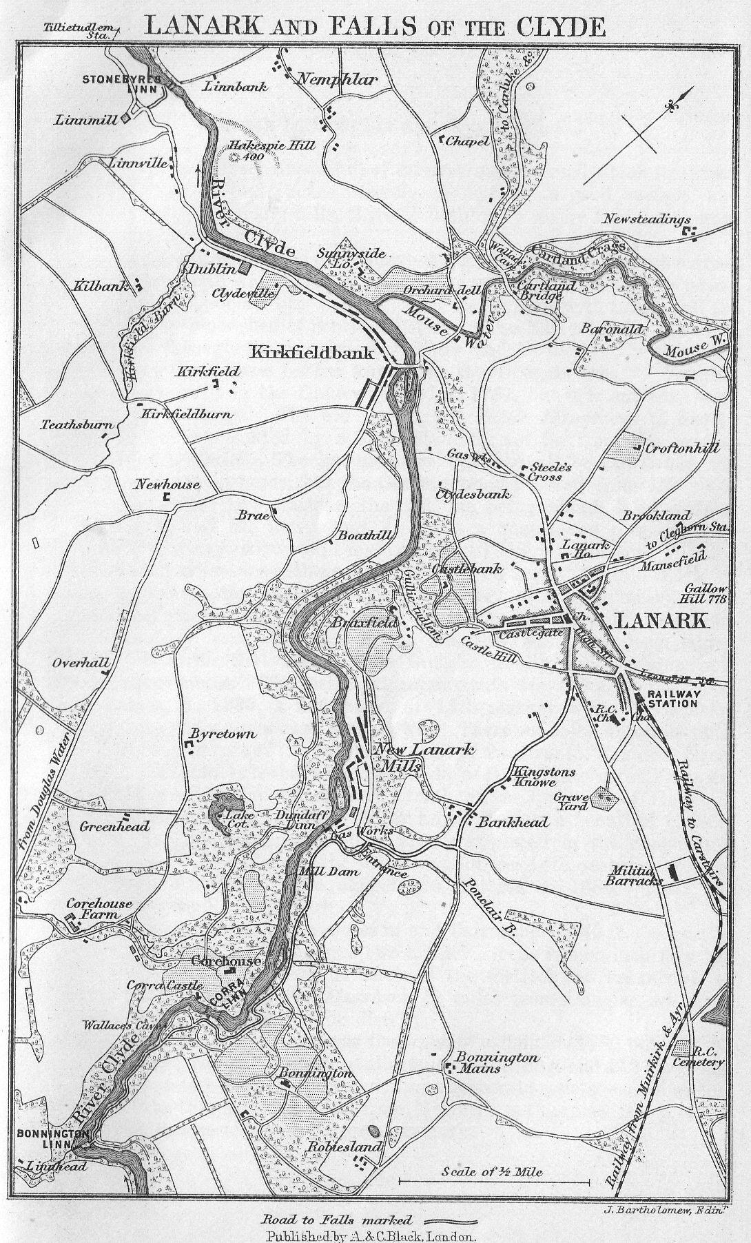
Lanark to Douglas and Ayr. (46 m.)
This cross-country line is full of interest, and the road which runs near it to Cumnock, and thence directly to Ayr, is of good surface, and though there are many hills, there is nothing so severe that an average cyclist need complain.
The railway crosses the river above the Falls, and runs through a green open valley with wide horizons and gently swelling fields, now so peaceful, and yet associated in the names of its owners with nearly all the turmoil and bloodshed of Scottish history. The Earl of Home inherited the land through his grandmother, sister and co-heir of the last Lord Douglas, after a cause celebre known as the Douglas case. Douglas Castle was built by the Duke who died in 1761, but it is only one wing of his great design. The old Castle, the Castle Dangerous of Scott's romance, is represented by a tower standing not far from the present magnificent Castle. The grounds are open to all comers when the family are not at home, but the Castle cannot be seen from the road. The village has two stations, the old one being about 4 miles from the village, and the new about 2. It is a quaint and pleasant little place with a very narrow odd main street. There is a neat and pleasant little hotel, where everything is clean and well kept. The old Kirk of St. Bride's is the chief object to see (key at cottage near). The hexagonal steeple, date 1618, with a bit of the ruined choir, dates from 12th century, and the rest of the small building has been added later. It forms the vault for the Douglas family, and contains some interesting tombs. The principal monuments are those of the Good Sir James, d. 1330, a fine piece of 14th-century work. His heart is enshrined in a silver case, also shown. There are to be noted in addition the monuments of the fifth earl; and of the seventh, James le Gros, d. 1443; the oldest is that to Marjory, wife of Hugh Douglas the Younger, d. 1259; and in the centre is the tomb of the Countess of Home, d. 1877, with an alabaster effigy by Sir Edgar Boehm, a beautiful piece of work. In 1904 a handsome stone altar was placed in the chapel and consecrated. The glass in the windows is of the 14th century, brought here from elsewhere. The chapel was restored in 1880. Near the chapel is a small public park.
After Douglas the valley closes in and Cairntable (1942 ft.) is seen to the south; then the line passes two artificial lochs from which flow the waters of the river Ayr. The whole of the district has its records of Covenanting times. With Muirkirk, 11 miles from Douglas, we come once more into a coal and iron district.
Airds Moss, to the west, was the scene of a fight in 1680 between 63 Covenanters, who had renounced allegiance to the king, and 112 dragoons. The Covenanters were overpowered after a desperate resistance. A monument marks the place. 9 miles from Muirkirk is Cumnock (see p. 445), and from thence to Ayr calls for no remark.
GLASGOW TO AYR
See maps, pp. 350, 360..
The route is by the Glasgow and South-Western Railway.
The first place of importance after leaving Glasgow is Paisley, where there is a joint station owned by the Caledonian in connection with the G. and S.W.
Paisley may also be reached by electric car from Glasgow.
Paisley
Hotels: Globe, George (temp.); two eighteen-hole golf courses in the neighbourhood. Pop. 79,350.
Paisley is a manufacturing town, a miniature Glasgow, and offers few attractions to outsiders beyond the beautiful old abbey. It stands on the banks of the White Cart, and was made into a royal burgh in 1488. The town is principally known for its thread-manufactories and is one of the largest thread-producing towns in the world. The famous Paisley shawls had their origin here, but they were superseded by the muslin and linen industries, and they in their turn by thread. The great liberality of the Coats and Clark families to the town where their factories are situated, shows itself in many fine public buildings, which will be treated in their turn. Any one coming out of the main station finds himself in an open space between the post-office and prison. If he walks straight forward he will presently come to the Town Hall, behind which is the Abbey, standing low, and not easily seen. The tram terminus from Glasgow is at the Town Hall.
THE ABBEY
(Admission 8d.)
The Abbey was founded as a priory in 1163 by Walter Fitzalan, first High Steward of Scotland, and the ancestor of the Stuart line. It was endowed for the souls of King Henry of England, King David, and King Malcolm, and dedicated to the Virgin, St. James, St. Milburga of Wenlock (whence its first monks came), and St. Mirrin or Mirinus, the patron saint of Paisley. In 1248 the priory became an abbey. It was partly burnt by the English during the Scottish wars with England, but rebuilt after Bannockburn.
At the first glance the exterior is somewhat disappointing; the west end is right out of the perpendicular; the tower, which fell some time before the Reformation, has been restored, but rises no higher than the ridgepole of the roof, though it is intended to heighten it eventually. The church has been well and carefully restored inside. The nave is in the transitional style of Decorated architecture, and contains six bays divided by massive pillars with well-moulded capitals. The transepts have been thoroughly restored, and the choir partly; in the untouched part the original walls stand to the height of ten feet, and the sedilia and piscina remain. A monument of Sicilian marble erected in 1888 marks the place before the High Altar where were buried the founder, his wife Marjory, and the wives of Robert II. and Robert III. The clerestory and triforium are of a very curious design and the window of the north transept retains its ancient tracery.
The chief gem of the Abbey is St. Mirrin's Chapel, which is on the south side. It was formerly called the "sounding aisle" from the strong echo. The views between the chapel and the nave should be noted, as they include some beautiful architectural compositions. In the chapel is a tomb, with a life-size recumbent woman's figure, supposed to represent Marjory, the daughter of Robert Bruce, and wife of the founder. She died in childbirth from the effects of an injury caused by a fall from her horse. There is also a memorial tablet to the last Abbot-Archbishop, John Hamilton, and a tablet put up by the first Lord Paisley in memory of his children. A series of bas-reliefs on the east wall of the chapel, representing scenes in the life of St. Mirrin, should be particularly noticed; they are very ancient, and are believed to have been part of the decoration of a Celtic cell which stood here before the building of the Abbey.
Turning now to the Town Hall, we notice at the north-east angle a statue of George Clark, who left a bequest of £20,000 with which the building was begun; a grand organ was afterwards presented by Messrs. Clark, who also completed the building at their own cost. So much does Paisley owe to her liberal citizens. The two firms of Coats and Clark by a recent combine have united the thread industry in Paisley. There are other manufactories in the town, but all come far behind the thread. Among these we may mention fancy and figure weaving, the manufacture of soap, starch, machinery, and some shipbuilding. A public park called the Fountain Gardens, 7-and-a-half acres in extent, was presented to the town by Thomas Coats.
On leaving the Town Hall, if we turn up the narrow main street, down which trams run every few minutes, a five minutes' walk brings us to a group of public buildings which would attract attention anywhere. Prominent among them, standing high, is the fine red sandstone Memorial Church built in memory of Thomas Coats by his family. The design is cruciform and the tower is surmounted by a crown. The whole gives the impression of great care and completeness, and the interior fittings are worthy of the building. Quite near it is the Drill Hall, and not far off are the Free Library and Museum in one building, erected at the expense of the late Sir Peter Coats, and the Observatory, a gift to the town by the late Thomas Coats, in whose memory the church was built.
No. 90 in the High Street is the house in which Christopher North was born. Another public park called the Brodie is named after its owner.
There are trams running all the way between Paisley and Glasgow, also between Paisley and Renfrew, and Paisley and Johnstone. Renfrew, though it gives its name to the county, is an uninteresting place; the chief object in it is a tall Town Hall steeple.
About 2-and-a-half miles south-east of Paisley are the ruins of Crookston Castle, where Queen Mary's bethrothal to Darnley is said to have been formally carried out.
About 3 miles to the south of the town are the Braes of Gleniffer, a favourite holiday resort, which appear frequently in the work of the poet Tannahill, who was a native of Paisley. The Braes rise to upwards of 700 feet at Duchal Law, commanding fine views; a road runs right across them, coming near to the line again at Beith.
Resuming the journey by rail, we pass Elderslie, the birth-place of William Wallace, and then see a line running off northward; this is the G. and S. W. line to Greenock (see p. 356); afterwards we pass through the manufacturing town of Johnstone (eighteen-hole golf course). At Kilbarchan, 2 miles west, there is in the town steeple a statue of Habbie Simpson in a niche; Habbie was the piper of Kilbarchan and was of great note in his day at the end of the 17th century. Lochwinnoch (golf course) stands more than a mile away from its station, near the end of Castle Semple Loch or Lochwinnoch, a favourite curling and skating resort. This loch is the source of the Black Cart River. During the last few years an association has been formed for preserving the fish in it: pike have been caught, and young trout introduced, so that the loch bids fair to become one of the best angling places within easy reach of Glasgow. Whatever charms the place may once have had, they have been destroyed by the smoke which belches forth from the tall chimneys. At the end of the loch is the mansion of Castle Semple with a large park. Here are the remains of a collegiate church, with a three-sided apsidal termination, founded by the first Lord Sempill in 1504. Not far from Lochwinnoch is a ruined tower called Barr House. Beith is also a mile or more away from its station. Kilbirnie stands very much in the same position to its loch that Lochwinnoch does to Castle Semple, but a branch rail goes right up to it. Kilbirnie Castle is a modern building, near an old ruin of the same name.
Dalry, which is next reached, is a large manufacturing place drowned in the smoke of the Blair ironworks.
From Dalry Junction the main line goes south-east to Kilmarnock, (see p. 444).
The Stranraer line, however, continues to Kilwinning (hotels, small), an old town with something more interesting in its aspect than the purely manufacturing places through which we have so far passed. The town takes its name from St. Winning, a bishop or abbot of the 7th or 8th century, whose name is also retained in Caerwinning Hill. There is in the centre of the town the fragment of an abbey, founded in 1140 by Hugh de Morville, Constable of Scotland, for monks of the Benedictine order. Freemasonry is said to have been first introduced into Scotland at Kilwinning, and the Kilwinning Lodge claims to be the parent of all the Scottish Lodges.
A mile from the town is Eglinton Castle (Earl of Eglinton and Winton). It is widely known as the place where the famous Eglinton tournament of 1839 was held, when Louis Napoleon, ex-emperor of the French, was present. The castle itself was built in 1800. The grounds are freely open to all comers on Saturdays throughout the year. Near Kilwinning the Caledonian Company's line to Ardrossan crosses the G. and S.W. Kilwinning is also the junction for the Ardrossan line of (G. and S.W. (see below).
Branch Line to Ardrossan, West Kilbride, etc.
From Kilwinning there is a branch line to Ardrossan, Stevenston, Saltcoats, West Kilbride, Fairlie, and Largs. At Stevenston are the Merry and Cunninghame ironworks, and among the sand-dunes on the coast, a mile south, is the factory of Nobel's Explosives Company, where the greater part of the dynamite and other powerful explosives used in engineering are made. Saltcoats (Hotel: Crown (C)) is an old-fashioned town with narrow streets, and a pier. Near it is the fine golf course of Ardeer, eighteen holes. Ardrossan (Hotel: Eglinton Arms) was projected by Hugh, twelfth Earl of Eglinton. The harbour, begun (1806-1819) at a cost of £100,000, has been greatly enlarged since. From Ardrossan there are numerous steamer trips to Arran (14 miles), and a variety of summer circular tours (one of a week's duration) to the Isle of Man, Liverpool, Dublin, and Belfast. After this there are splendid views of the Mountains of Arran before we reach West Kilbride (inn); Law Castle is on the right of the station. Other 4 miles north we reach the seaside village of Fairlie - Kelburne Arms, famous for its yacht-building, and with an old watch tower. Fairlie Glen is a pleasant picnicking resort, and the ruins of the castle, built about 1520, add a touch of historical interest. From Fairlie the turbine steamers for Campbeltown may be boarded (see p. 365). Proceeding up the coast, we pass, on the right, Kelburne Castle (seat of Earl of Glasgow) and reach Largs.
Largs (Hotels: Royal (C); White Hart (C); nine-hole golf course) is one of the yachting centres of the Clyde. It has been called the "Town of Spires." The battle of Largs in 1263 between Haco of Norway and Alexander III. of Scotland, which so altered the whole course of Scottish history, was fought partly on the ground on which the town now stands. Haco was defeated and fled to his ships to die in Orkney (see Scotland, North, p. 262).
There is no doubt that a railway connection between Largs and Wemyss Bay is greatly needed; the difficulty lies in the fact that the Wemyss Bay terminus is Caledonian, and the line by which we have come G. and S.W., but it is to be hoped a compromise may be arrived at. The road between the two passes the Skelmorlie golf course of nine holes.
Close to the coast by Largs and Fairlie lie the Cumbrae Islands, with their curious reared-up stratified rocks. The chief town of Great Cumbrae Island is Millport (Hotels: Cumbrae; Royal George; Kelburne; nine-hole golf course), a summer resort stretching for about 2 miles along a bay on the south. There are a good pier and harbour. The picturesque marine residence called "The Garrison" stands in the centre of the village. The College and Collegiate Church, opened in 1851, are graceful Gothic buildings occupying a fine site on a rising ground behind the town. In 1876 the Collegiate Church was consecrated as the Cathedral of the Isles, and there is daily service. Noteworthy also are the Marine Biological Station and the Lady Margaret Hospital (for infectious diseases), the latter a red sandstone building overlooking the bay. With a southern exposure, Millport has a warm but bracing atmosphere, and a drier climate than the surrounding districts of Ayrshire and Argyll. The island is 4 miles long by 3 broad. There are good roads round and across it, and during summer a service of cars. The north end is low, but in the east and west towards Millport the coast shows bold cliffs and a rocky shore. There are numerous basaltic dykes running through the island, one of which, on the east shore, known as the Lion Rock, assumes a grotesque representation of a lion entering a cave.
The Little Cumbrae lies 1-and-a-half mile to the south of Millport. On its southern shore are a number of caves wrought in the stratified rocks by the action of the sea, the largest of which is called the King's Cave. On a small island, off the eastern shore, are the ruins of an old embattled square tower, said to have been a safety retreat of the Eglinton family. The ruins of the chapel and tomb of St. Vey are near the top of the small hill in the island, the property of the Earl of Eglinton.
The mid-day and evening steamers cross from Millport to the sweet little bay and hamlet of Kilchattan, in the south of Bute (p. 358).
Resuming the line to Ayr where we left it at Kilwinning, we soon reach Irvine, with several small hotels, including King's Arms (C). This is an old royal burgh with a population of 9618, standing near the mouth of the river Irvine. The main street is wide, and mostly cobble paved, and the whole town has an air of sleepiness in spite of its large shipping connection. In truth the activity is mainly confined to the seaward end. There is a golf course of eighteen holes (Bogside) northward. In a back street is an old building called the Castle, where a bit of cable moulding on the windows, and a doorway with dog-tooth ornament, speak of departed days of grandeur. John Galt, author of Annals of the Parish, was born here in 1779, and also James Montgomery the poet, in 1772. It was at Irvine that Burns for nearly a year struggled to earn a living as a flax-dresser.
After leaving Irvine the ruins of the old castle of Dundonald may be seen about 2 miles to the east. King Robert II. died here in 1390. Near it are the remains of an old church called Our Lady's Kirk of Kyle to which King James IV. made offerings. Between Irvine and Troon the line skirts the eighteen-hole golf course of Gailes. The famous golfing resort, Troon, is next reached. (Hotels, see below).
It is a curious place and very widely extended. The huge crescent beach stretches for 2 miles, and ends in the lighthouse. The streets are laid out regularly in rows of neat red houses. The harbour was made by the Duke of Portland at a cost of more than £50,000, and from it large quantities of coal are embarked. Fullarton House, a seat of the Duke's, stands about 3 miles south-eastward.
There are three hotels: the huge Marine, latest style, terms from 10s. 6d. per day, near the golf links, also the South Beach and the Mar Lodge, smaller and modern and comfortable. The Troon and Prestwick links run on continuously, and are certainly wonderful, there being no less than seven courses of eighteen holes between the two places, and of these the Municipal Links are the longest in Britain. From the hotel there is a fine view of the hills of Arran, but the place itself is wind-swept and unsheltered, and the country somewhat uninteresting, and not wholly free from chimneys. The line goes southward to Prestwick, the rival golfing station, where, strange to say, in spite of good links, there is no first-class hotel. The reason doubtless is that Ayr is now brought so near by electric trams that golfers prefer to stay there and come to and fro. Prestwick, it must be noted, is a very quiet little place without any attraction save its links.
Only 3 miles farther on is Ayr.
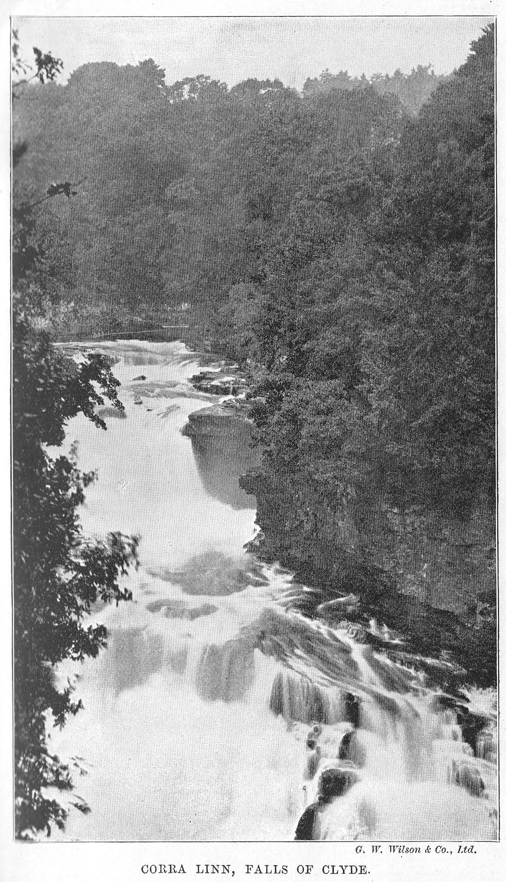
AYR AND THE LAND OF BURNS
Hotels: Station, very large, belonging to railway company, with modern luxuries, on same footing as St. Enoch's in Glasgow and Station at Dumfries; King's Arms, and others. Population, 29,100.
The electric cars run from Prestwick Cross right through the town to Alloway, so that it is possible to see Burns's Cottage and Monument very easily.
Ayr is an attractive place, with a curious mingling of quaintness and modernity. The large number of visitors has enabled it to afford such things as a really first-class hotel and electric trams, and a becoming spirit of reverence for its past causes it to retain with care any ancient relics. The long winding main street runs to a great distance in the Prestwick direction, and is as a rule very narrow.
On arriving at Ayr station, and passing beneath the fine hotel, we see first, in the open space in front, the Burns's Statue and a memorial to the Royal Scots Fusiliers who fell in South Africa. Turning right into the High Street we catch sight of the Wallace Tower, built in 1832 - the original Wallace Tower in which the patriot was said to have been kept a prisoner was a rude old building at the head of Millvennel, which was destroyed and replaced by this. On the same side as the tower a narrow lane, Kirkport, runs down to the river, and by following it we shall come to the old church, built in 1655 on the site of the Greyfriars' Monastery, and probably with the same old stones. Continuing down the High Street, we see another statue of Wallace, set in the house which stands on the site of the old tower already mentioned. Then we come to "The Twa Brigs," old and new.
The old one was built in the reign of Alexander III. (1249-1285) by two maiden ladies, whose effigies are still to be seen in the parapet. This bridge has recently been condemned as unsafe, but such an outcry was aroused about its demolition, it is probable it will be patched up to stand many years yet. The new bridge is not that referred to by Burns, which indeed fell before it had been in existence a hundred years, and was replaced by the present wide one in 1877. Even that proved insecure shortly afterwards, so that the prophecy which Burns put in the mouth of the "Auld Brig" came literally true –
Conceited gowk! puff'd up wi' windy pride!
This monie a year I've stood the flood an' tide;
And tho' wi' crazy eild I'm sair forfairn,
I'll be a Brig when ye're a shapeless cairn!
A third bridge, the Victoria, at the south-east end of the town, beyond the railway bridge, was opened in 1898. Near the east or Ayr side of the new bridge is the King's Arms hotel, and the modern town buildings with a tall spire.
Crossing the bridge we are in the suburb of Newton, where is the handsome free library.
Returning once more by the new bridge, we can turn down to the harbour, which in early times was a very flourishing port. It was from here that Bruce embarked for the purpose of invading Ireland. Recently a large dock has been built, and considerable improvements made on the south of the harbour, including a fine esplanade. Shipbuilding is carried on to a large extent. The views from the bay include the hills of Bute, Arran, and Ailsa Craig.
The sea-coast, which near the town is comparatively flat and sandy, rises on the south into bold rocky headlands, among which are "The Heads of Ayr," well known to seamen. About midway between these and the harbour are the ruins of Greenan Castle.
The fragments of a fort between the town and the sea are the work of Oliver Cromwell, who built it in 1652. He had found the site where stood the old church of St. John a suitable situation, so he took it and paid the citizens £150 towards the erection of another church already noticed. The Castle of Ayr, built by William the Lion, who constituted Ayr a royal burgh, is supposed to have stood at the north-eastern angle of the fort, close upon the harbour.
Along the flat shores to the south of the town is the racecourse, which, at the time of the Western meeting at the end of September, brings such a concourse of undesirable people to the town that all quiet travellers would do well to avoid it.
Burns's Cottage, Monument, and Alloway Kirk
By means of the electric cars, or on foot or bicycle, along a pleasant tree-shaded road, some of the more interesting scenes connected with the poet Burns may be visited. The town is no sooner left than various localities are reached mentioned in "Tam o' Shanter." 2 miles south of the station and 150 yards from Slaphouse Bridge is
The ford,
Whare in the snaw the chapman smoor'd.
About 100 yards from the "ford," and about 20 from the road, in the plot of ground behind the house occupied by the Rozelle gamekeeper, is the
Meikle stane,
Whare drunken Chairlie brak's neck-bane.
Passing on the left the mansion of Rozelle, at a distance of about 2 miles from Ayr, we reach the cottage where Burns was born, 25th January 1759. The original erection was a clay biggin, consisting of two apartments, the kitchen and the spence or sitting-room. The cottage was built on part of 7 acres of ground, of which Burns's father took a perpetual lease from Dr. Campbell, physician in Ayr, with the view of commencing business as nurseryman and gardener. Having built this house with his own hands, he married, in December 1757, Agnes Brown, the mother of the poet; and after becoming gardener and overseer to Mr. Ferguson of Doonholm (now James Kennedy), he abandoned his design of forming a nursery. He continued to reside in the cottage till Whitsunday 1766. On removing to Lochlea he sold his leasehold to the Corporation of Shoemakers in Ayr.
The contrast between the bare simplicity of the cottage itself, with its rough-cast walls and thatched roof, and the highly polished-up surroundings is almost ludicrous. One goes through a turnstile and pays twopence, whereupon one is admitted to an expanse of beautifully-kept green lawn with flowers round it, and one can sit under the verandah of a building like a club golf-house, or go inside to see the relics there collected. By far the most interesting items in this collection are the original MS. of Burns's poems; a perfect copy of the first, or Kilmarnock, edition of the same (bought for £1000); and Burns's family Bible, with entries in the poet's handwriting (bought for £1700). In the cottage itself there are some bits of furniture connected with the poet, and in the kitchen the old dresser, recess-bed, etc., which make it look as he must have seen it.
On an eminence about 1-and-a-half miles to the south-east of the cottage stands the farm of Mount Oliphant, to which Burns's father removed on leaving the cottage, and where the family lived for eleven years. Proceeding towards Burns's Monument, we perceive in a field a single tree, enclosed with a paling, the last remnant of a group which covered
The cairn
Whare hunters fand the murder'd bairn.
The position of the "cairn," and also of the "ford," at a distance from the highway, is accounted for by the old road from Ayr, by which the poet supposed his hero to have approached Alloway Kirk, haying been to the west of the present line. Beyond this stands
Alloway's auld haunted Kirk,
roofless, but with walls pretty well preserved, and still retaining its bell at the east end. The woodwork has all been taken away to form snuff-boxes and other memorials. In the area of the kirk the late Lord Alloway, one of the Judges of the Court of Session, was interred; and near the gate of the churchyard is the grave of Burns's father, marked by a plain tombstone, a renewal of the original, which was carried away in fragments. Near the ruined kirk, between 200 and 300 yards oif the public road, is Mungo's Well,
Whare Mungo's mither hang'd hersel'.
It is reached by a footpath, and the spot, beyond its interest, is to the spectator one of the loveliest on the banks of Doon.
Before him Doon pours all his floods;
The doubling storm roars thro' the woods.
The river Doon, to which the writings of Burns gave celebrity, rises in a loch of the same name, about 8 miles in length, situated in the mineral district of Dalmellington (see p. 458). The river has a course of 18 miles, throughout which it amply sustains its right to the title of "Bonny Doon."
The new parish church of Alloway stands on the opposite side of the road from Mungo's Well, and in the immediate vicinity are the mansions of Cambusdoon (Mrs. Baird), Doonholm (James Kennedy), and Doonside (W. H. Dunlop).
Burns's Monument, which stands close by on a conspicuous position, is a building in the usual style of the first few decades of the 19th century, when taste was at its lowest ebb. It matches the Burns's monument in Edinburgh, and the cost was upwards of £3300. In a circular apartment on the ground floor there are exhibited several appropriate articles - various editions of the poet's works, a snuff-box made from the woodwork of Alloway Kirk, a copy of the original portrait of Burns by Nasmyth, and the Bible given by Burns to his Highland Mary. In a small grotto at the south side of the enclosed ground are two statues of Tam o' Shanter and Souter Johnnie, by Mr. Thom of Ayr.
The electric cars run as far as the new bridge, where stands the Burns Arms Inn (and tea gardens), through which admission to the wooded banks of the river can be obtained (2d.). The old and new bridges are somewhat reminiscent of those near Aberdeen.
Burns's subsequent career takes us to a more distant part of the county, and to the north-east of the town of Ayr. Burns's father, on the death of his landlord, Provost Ferguson, removed from Mount Oliphant, in 1777, to Lochlea, in the parish of, and 8 miles from the village of, Tarbolton (inn), that can be reached by rail (7 miles) from Ayr, by the line to Mauchline. While residing in this farm the poet established a Bachelors' Club in Tarbolton, in the latter part of the year 1780; and here, in 1783, he was initiated into the mysteries of freemasonry. About 200 yards north of the village on the road leading to Galston, lies the scene of "Death and Dr. Hornbook." "Willie's Mill," alluded to in the poem, was the Mill of Tarbolton, situated on the Faile, about 200 yards east of the village, and was called by the name used in the poem in consequence of its being then occupied by William Muir, a friend of the Burns family. About half a mile from Tarbolton stands the mansion-house of Coilsfield, designated by Burns "The Castle o' Montgomery," from its being in his time the residence of Colonel Hugh Montgomery, afterwards Earl of Eglinton. Here Mary Campbell, Burns's "Highland Mary," lived in the humble capacity of dairymaid. And in this neighbourhood, near the junction of the river Faile with the Ayr, lies the scene of the parting which the poet has described in such exquisite terms.
According to unvarying tradition, Coilsfield derived its designation from "Auld King Coil," who is said to have been overthrown and slain in this neighbourhood in a battle with Fergus, King of Scots. Burns alludes to this tradition in his poem of "The Vision":-
There where a sceptred Pictish shade
Stalk'd round his ashes lowly laid,
I mark'd a martial race, portray'd
In colours strong;
Bold, soldier-featured, undismay'd
They strode along.
The "martial race" here referred to are the Montgomeries. Coilsfield has now the more poetic name of "Montgomerie."
On the death of Burns's father, his widow and family removed to Mossgiel, a farm about a mile north of the clean and neat village of Mauchline {Hotels: Loudon Arms; Springfield (C and temp.)), which the poet and his brother Gilbert had taken some months before. Here Burns lived from his 25th to his 28th year, the period during which he wrote his principal poems. The spence of this farmhouse is the scene described in the opening of "The Vision," and in the "stable-loft," where he slept, many of his most admired poems were written. The village is prettily situated on the face of a slope, about a mile from the river Ayr, and contains about 1767 inhabitants. It is famed for its manufacture of snuff-boxes, etc., and its horse fairs; and it was the scene of the "Holy Fair," and of the "Jolly Beggars," and here dwelt John Dove, Nanse Tinnock, "Daddy Auld," and other characters who figure conspicuously in the poet's writings. The churchyard was the scene of the "Holy Fair," but the present church is a recent substitute for the old barn-like edifice which existed in Burns's time. Near the church is the "Whitefoord Arms Inn," where Burns wrote on a pane of glass the amusing epitaph on the Landlord John Dove. Nearly opposite the churchyard gate is the house of "Auld Nanse Tinnock," bearing over the door the date 1744. "Poosie Nansie's," the scene of the "Jolly Beggars," is still a popular little inn. Close behind the churchyard is the house in which Mr. Gavin Hamilton, the early friend of Burns, lived, and here is shown the room in which Burns composed the satirical poem entitled "The Calf." This room is further remarkable as the one in which the poet was married.
The scenes of some of Burns's most admired lyrics are to be found on the banks of the river Ayr, at a short distance from Mauchline. The "Braes of Ballochmyle," the scene of his exquisite song "The Lass o' Ballochmyle," are situated a mile from the village, extending along the north bank of the Ayr, between Catrine and Howford Bridge. They form part of the pleasure-grounds connected with Ballochmyle House (Sir Claud Alexander, Bart.), which was at one time the property of the Whitefoords, an old and once powerful Ayrshire family. Colonel Allan Whitefoord, one of the members of this family, was the original of the character of Colonel Talbot, described in the novel of Waverley. Another of them, Caleb Whitefoord, "the best-natured man with the worst-natured muse,' has been immortalised by Goldsmith in a postscript to his witty poem entitled "Retaliation." Sir John Whitefoord, the representative of the family in the time of Burns, having been forced to part with his estate in consequence of reduced circumstances, Burns wrote some plaintive verses on the occasion, referring to the grief of Maria Whitefoord, afterwards Mrs. Cranstoun, on leaving the family inheritance:-
Through faded groves Maria sang,
Hersel' in beauty's bloom the while;
And aye the wild-wood echoes rang,
Fareweel the braes of Ballochmyle.
Ballochmyle was purchased by Claud Alexander, and shortly after he had taken possession of the mansion, his sister Miss Wilhelmina Alexander, a famed beauty, walking out along the braes one evening in July 1786, encountered Burns, musing as he leaned against one of the trees. The result was that the poet, during his homeward walk, composed the well- known song above alluded to. The spot where the meeting took place is now distinguished by a rustic grotto or moss-house, ornamented with appropriate devices, in the back of which there is devised on a tablet a facsimile of two of the verses of the poem, as it appeared in the holograph of the author.
Near Ballochmyle is the manufacturing village of Catrine, famous for its big wheel, second only in size to that of Laxey, in the Isle of Man. Close by was the seat of Dr. Stewart, father of Professor Dugald Stewart. To them Burns alludes in the following stanza in "The Vision":-
With deep-struck reverential awe
The learned sire and son I saw;
To nature's God and nature's law
They gave their lore;
This all its source and end to draw,
That to adore.
Barskimming House (Sir W. Miller of Glenlee, Bart.), 2 miles from Mauchline, is romantically situated on the banks of the Ayr, whose scenery here is very beautiful. Barskimming and its then proprietor, Lord President Miller, are thus alluded to in the above poem:-
Through many a wild romantic grove,
Near many a hermit-fancied cove,
Fit haunts for friendship or for love,
In musing mood,
An aged judge, I saw him rove,
Dispensing good.
A short distance farther up the river, near the point where the Lugar joins, is the spot where Burns composed the poem entitled "Man was made to mourn."
Mauchline (p. 445, connected with Ayr by a branch line of rail) is on the main South-Western line from Glasgow to Dumfries.
8 miles S.E. of Mauchline, on the main line (past Auchinleck village, inn', and House-built by the father of James Boswell, and visited by Dr. Johnson), is the pleasant, sheltered town of Cumnock (pop. 3088 - Dumfries Arms) on the Lugar Water, near which are some valuable minerals. At Cumnock is buried the Prophet Peden (see p. 445). Here the Caledonian Railway's line from Edinburgh to Ayr (vid Carstairs and Lanark - p. 436) crosses the South-Western line at right angles. On the former, 10 miles north-east from Cumnock, is Muirkirk (inn), with large ironworks. On the rather bleak hills around there is good grouse and other shooting.
Ayr to Dalmellington, etc. (see p. 457, reverse way).
Ayr to Stranraer {main line continued, see p. 425).
GLASGOW TO ABERFOYLE
See map, P. 374.
From Glasgow trains run by Cowlairs and Lennoxtown, before which there is nothing of any interest to remark upon. From Lennoxtown, or the next station, Campsie Glen, Campsie Glen itself may be ascended. This beautiful glen is a favourite place of summer resort, and leads up into the heights of the Campsie Fells. The next station on the line is Strathblane, lying between the Campsie and Kilpatrick hills. At this point the most direct road between Glasgow and Aberfoyle joins the line, and with it proceeds up the valley. Just before Gartness station we cross the Endrick Water, and are joined by the line from Balloch, by which an alternate route from Glasgow may be made.
To the west lies Buchanan Castle (Duke of Montrose); continuing north-eastward, in a narrow pass between the hills, often made use of in the old reiving days, we come to the junction at Bucklyvie, whence the main line goes on to Stirling, and the branch turns up northward to the terminus at Aberfoyle.
ABERFOYLE
Hotels: Bailie Nicol Jarvie; Aberfoyle Temperance* (C). Nine-hole golf course.
At the former hotel terms are by tariff only in the season. The smaller hotel, MacKellar's Temperance (terms, £2:10 and £3 per week), is both comfortable and pleasant. Aberfoyle is a bright little place standing at the foot of the wooded Craigmore, which, though only 1271 feet, rises so abruptly as to seem much more.
This is all historic ground, for, as the meeting-place of Highlands and Lowlands, many were the scenes here enacted. The most famous of all, for in the hands of the magician fiction became fact, was that exciting scene when the Bailie Nicol Jarvie and young Osbaldistone arrived wearied out at the Clachan and were refused shelter at the rough inn because "three Hieland shentlemens" wanted the place to themselves. The landlady said her house was taken up "wi' them wadna like to be intruded on wi' strangers." The row that subsequently took place, in which the stout little Bailie defended himself with a red-hot coulter of a plough, is too well known to need quotation. Suffice to say that a coulter, traditionally said to be the very weapon, hangs on a tree outside the hotel which bears his name to this very day. Very different are the luxuries that now await the traveller at Aberfoyle from those of the primitive shieling, with its discoloured walls, broken roof, and mud floors.
The earlier part of the Forth, here known as the Laggan, runs past the little town, and the old saying, "Forth bridles the wild Highlandman," becomes significant.
Aberfoyle is in the district of Menteith, which at one time was one of the five large divisions of the then known Scotland. About 4 miles westward is Lake Menteith, on an island of which the Earls of Menteith (Graham) had their residence. There is a larger island, called Inchmahone, on which are the ruins of a priory, where Queen Mary spent a year of her childhood. The loch is about 2 miles long and a mile broad. Near Port of Menteith, on the north side, is an hotel, from which boats run at regular intervals to the islands.
Inchmahone means the "Isle of Rest," and the name at present suits it well. There are the monastic ruins in the Early English style, and a western door, richly moulded. Also a large monument, with two recumbent figures on it. The church was founded by the Earl of Menteith early in the 13th century.
Little Queen Mary, then only five years of age, was brought here after the battle of Pinkie, and the following year went to France to be betrothed to the dauphin. There are some fine trees on the island, which probably overshadowed with their leaves the head of the little girl who was to cause more discussion, more excitement, than any other queen that ever reigned in England or Scotland.
On Inch Tulla are the remains of the fortress stronghold of the Earls, now in ruins.
Beyond Lake Menteith a branch of the road goes north over a stiff hill (566 ft.) to Callander, and the main part continues to Thornhill, whence it branches to Doune and Stirling.
Aberfoyle to Stronachlachar (12 m.)
This is a pass through which many a band of military men have come intent on suppressing the wild Highlanders. General Monk passed this way, having previously sent a letter to the Earl of Airth anent the cutting down of the woods, "Which are grete shelters to the rebelles and mossarsers." It was up the pass of Aberfoyle, too, that the Bailie and Osbaldistone went unwillingly with the escort of soldiery, as described in Rob Roy; and here they were set upon by the redoubtable Helen Macgregor and her men, and ran a narrow escape from a sudden and ignominious death.
The route seems perpetually up and down, but is in reality mostly a rise. After rain the first part of the way, being beneath trees, is an almost impassable sea of mud. Loch Ard is supposed to have been the loch Scott had in mind when he told of Helen Macgregor's vengeance on the gauger Morris, though even the inhabitants do not point out the exact rock from which the unhappy man was precipitated into the water. The fishing, which is good, is free to people staying in the hotel at Aberfoyle, though the charge for boat and boatman (seven shillings per day) is heavy. The loch sport begins as early as March, and continues good for the next four months; the fish are supposed to be almost equal to those of Loch Leven. Not far off is Duchray Castle, near which runs the Duchray Water; this is one of the main streams which combine to form the Forth - trout fishing free. Near the north or west end of Loch Ard, a little off the road, the Ledard comes down in some Falls. For the next 5 miles the road rises almost all the way, though the ascent is disguised by minor drops. It passes Loch Chon (pron. Con), which can be fished from Stronachlachar or Aberfoyle hotels at the same charge for boat, etc., as Loch Ard. The sport is good. From here there is a very steep pull up, amid more open and wilder scenery, and then a rapid fall to the cross road between Inversnaid and Stronachlachar, from whence it is only half a mile to the Stronachlachar Hotel.
GLASGOW TO INVERARAY
See maps, pp. 360, 394.
(i.) Via Arrochar.
(ii.) Via Loch Goil.
The railway companies run steamers to Loch Long and Loch Goil; timetables can be obtained on application to either the Caledonian or North British Companies. For Lochgoilhead a steamer leaves Glasgow every day at 9 A.M.
For the first part of the journey up the Clyde, see p. 352.
Most of the Loch Long steamers call at Hunter's Quay, near Kirn, and passing the mouth of Holy Loch stop at Blairmore and Ardentinny, from which a road runs across the peninsula to Whistlefield on Loch Eck. For Loch Eck, etc., see p. 398.
From Ardentinny the Kilmun hills extend south-westward, while numerous Cruachs and Bens, attaining heights varying from 10,00 to 2000 feet, rise on the north of the bay.
Not long after Ardentinny the entrance to Loch Goil opens on the west.
(ii.) Loch Goil is about 6 miles long and 1 to 2 miles in breadth. On entering the loch the hills on the east are bold and steep, covering the district known as Argyll's Bowling-Green (see below). On the west are the ruins of Carrick Castle on a rock. Tradition says this castle was built by the Danes. But the present building certainly does not date farther back than the 16th century. It was once a royal castle, and in William III.'s reign was placed in the keeping of the Marquis of Argyll. It was subsequently burnt by the men of Atholl. The entrance to Loch Goil has often been taken as the scene of Campbell's poem, Lord Ullin's Daughter, which, however, is more correctly placed in Mull.
There is an hotel at Lochgoilhead; and in the church may be seen some of the tombs of the Campbells of Ardkinglass and Strachur. Ben Donich (2774 ft.) and Glencroe are the highest hills in the vicinity. A coach meets the steamer and takes passengers by Hell's Glen to St. Catherine's Ferry on Loch Fyne (see p. 398).
Passing the mouth of Loch Goil, we reach Portincaple, where there is a ferry and a road across to the Gareloch (p. 415). Beyond this, northwards, Loch Long is not more than two-thirds of a mile in breadth. At this more secluded part, on the east side, lie the beautiful seats of Finart and Ardarroch. In sailing up, we have now an excellent view of the Arrochar range of hills, conspicuous among which are The Brack (2500 ft.) and Ben Arthur, or the "Cobbler" (2750 ft.), whose rocky summit is cracked and shattered into various fanciful forms.
The splendid estate which Mr. Cameron Corbett, M.P., has gifted to Glasgow lies between Loch Long and Loch Goil. It is about 6 miles long and 6 miles broad at the northern end, and includes altogether 9000 acres. The district is rugged and grand, a veritable piece of wild nature, at present inaccessible save by steamer. The mountains breed black game, grouse, woodcock, roe-deer, pheasants, hares, and rabbits, and on the slopes are pastured more than two thousand sheep, while three farms are included in the gift. The estate is known as Ardkinglass.
Arrochar (Hotels) is a quaint little place. The principal hotel was burnt two years ago, but reopened in the season of 1906 {terms, 3 guineas per week). It stands near the head of the pier; Ross's Hotel near head of loch (2 guineas to £2: 10s. (C)). There are a few small shops, post-office, etc., and farther southward a very small temperance inn and tea garden. Excursions are run in summer from Glasgow by steamer, so that Arrochar is sometimes invaded by hundreds of people in an afternoon. Arrochar shares a station with Tarbet on the West Highland line, and this lies about 2 miles from the village.
A pleasant circular tour may be made by going over to Tarbet, and returning by steamer on Loch Lomond to Balloch, thence train to Glasgow.
The glen leading northward from Arrochar runs up to Loch Sloy deep in the hills. Loch Sloy was famous as the rendezvous of the Macfarlanes (see p. 371). Its name was their Slogan; and as the clan generally chose full moon for descending on marauding expeditions from their native fastnesses, the moon came to be called locally "Macfarlanes' lantern."
As there are now no coaches running through Glencroe, the rest of the way must be made on foot or by cycle. Starting from the pier the road winds round the head of Loch Long. It skirts the western shore until it arrives at Ardgarten House, from whence it turns northward up the desolate Pass of Glencroe.
The ascent of the Cobbler may be made from Ardgarten. The road through Glencroe was constructed by the 22nd regiment, and involves a climb over a loose bad surface; near the summit the rise is very steep. After one tremendous zigzag, a road comes in on the west from Hell's Glen. Here a seat called Rest-and-be-Thankful has been put up, and is alluded to by Wordsworth:
Doubling and doubling with laborious walk,
Who that has gained at length the wished-for height,
This brief, this simple wayside call can slight,
And rest not thankful?
Passing on the left a small sheet of water called Loch Restil, the road descends towards Loch Fyne by the side of the Kinglas Water; the descent is steep and dangerous. On reaching the loch side, where it is joined by the road from St. Catherine's (p. 398) on the south, there is, on the left, the triple-turreted castle of Ardkinglass (G. F. W. Callander), an old seat of a cadet of the Campbell family. Turning northwards along the shore a little beyond this, Cairndow church, hotel, and school are passed on the right, after which the road keeps round the head of Loch Fyne, where the surface is very good. From the head of the loch a road runs up Glen Fyne, being feasible for about 6 miles, when it ends in the hills at the foot of Ben Buie (3106 ft.). Almost opposite (and 5 miles from) Ardkinglass are the ruins of Dunderave Castle, a stronghold of the MacNaughtens. The castle, consisting of a strong tower with turrets at each angle, is built close upon the seashore, from which it must usually have been approached. Round Strone Point we reach Loch Shira, a bay on Loch Fyne, hence an excursion may be made up Glen Shira, at the entrance to which is Dubh (black) Loch. At the head of Glen Shira is a house popularly known as Rob Roy's house. A smooth road of about a mile and a half brings us over Aray Bridge and past the castle grounds to Inveraray, see p. 395.
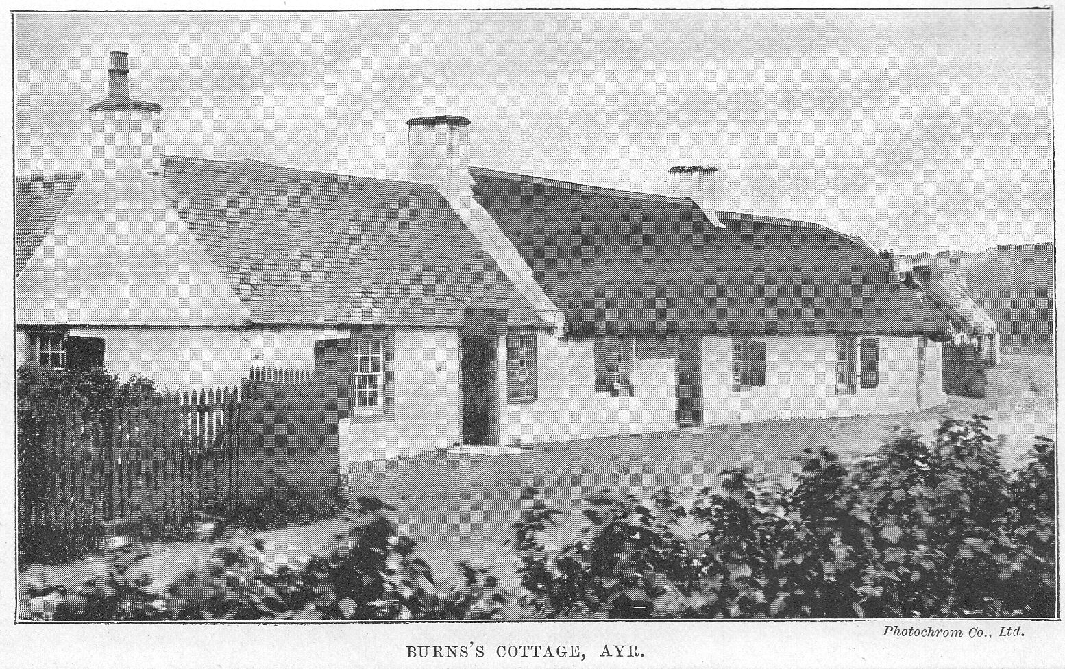
GLASGOW TO ARRAN
See map, p. 350.
ARRAN may be reached from Glasgow-
1. By ARDROSSAN (the easiest and most expeditions route), via the Glasgow and South-Western Railway (St. Enoch's) to Ardrossan (p. 331). The Company runs fine steamers in connection with its trains. Visitors can go via Brodick to Whiting Bay and thence by coach to Kildonan and Lag.
2. By swift steamer round the Kyles of Bute (p. 352). The steamer may be reached either by Craigendoran Pier, HELENSBURGH (via the North British Railway); or by Prince's Pier, GREENOCK (via the South-Western Railway); or by GOUROCK or WEMYSS BAY (vid the Caledonian Railway).
3. By other steamers from Glasgow in the morning, via Greenock, Gourock, Dunoon, Rothesay, etc.
4. By the CAMPBELTOWN (Kintyre) steamers, calling at Greenock and Gourock and - in the season - at Fairlie (p. 331) on the Ayrshire coast, to Loch Ranza in Arran, and thence down the Kilbrannan Sound. This boat runs to Lochranza and Campbeltown, returning in the afternoon.
ARRAN
Arran is familiar to many who have never set foot upon it, for its high serrated peaks are conspicuous over miles of sea. It is about 20 miles long and 11 broad, and its scenery is exceedingly beautiful. The population of the whole island is 4766. Its geology is varied, showing in a small compass most of the successive geological formations of the earth. For the botanist there are wild flowers and species of plants rarely found elsewhere. Though the numerous whitewashed cottages dotted about its shores are in summer one and all let to lodgers, the place still retains its charm, and is not vulgarised. It belongs to Lady Mary Hamilton, only child of the 12th Duke of Hamilton, with the exception of the one estate of Kilmichael, near Brodick, held by A. L. F. Robertson-Fullarton, who still preserves the original charter by which it was granted to his ancestor by Robert Bruce. Every district shows signs of the personal interest taken by the lady of the island in her tenantry, and if the prohibitive notices as to trespass, fishing, etc., are rather exasperatingly in evidence, it must be remembered that the same care which provides for their distribution has kept the island as free from taint of vulgarisation as it is. There are golf courses on the island at Brodick, Corrie, Lamlash, Shisken, and Whiting Bay.
Lamlash is the capital, but Brodick is the better known place, and therefore in giving a rough sketch of the island Brodick is taken as the starting-point. As a matter of fact there is no village of Brodick now, though the district retains the name. The village was demolished in order to make a better approach to the castle, and the existing village near the pier is correctly that of Invercloy. Close to the pier is the large Hotel, excellently managed, and with a certain amount of exclusiveness, which can be best expressed by saying it is the opposite of commercial (terms, 3-and-a-half guineas per week). The scattered village contains a few small shops, post-office, etc.; pretty widely separated are the three churches, Free, United Free, and Established. There is a good golf course of eighteen holes, and a number of bathing machines for the use of visitors. Here, as elsewhere, lodgings of a simple sort abound and are well patronised in the season. The view from just below the hotel - for the hotel itself is too much shut in by trees - is very fine. We can see the sweep of the bay with the sharp sides of towering Goatfell rising above it, and on its lower slopes the castle in which the chief historical reminiscences of Brodick are centred. The building as it stands is not old, having been largely reconstructed in 1844, but part of the older castle is still left standing. Even this is not the same castle as that which was taken by the followers of Bruce before the arrival of the Bruce himself.
The king, having been for some time on the small neighbouring island of Rathlin beyond the Mull of Kintyre, his undaunted follower Douglas began to chafe at the inaction, and obtaining leave he took with him Sir Robert Boyd and a few followers and landed at daybreak in Arran. At that time the castle was occupied by Sir John Hastings, and three vessels, laden with food and other supplies, had just arrived for the garrison. The followers of Douglas attacked the men who were carrying these things up to the castle, and easily obtained a supply of the booty; however they could not get into the stronghold itself for the gates were immediately closed. Shortly after, the king himself landed at Loch Ranza (see p. 349). Then the castle was taken, and King Robert established himself there to watch for a summons from the shores of the mainland. He had sent out a follower to reconnoitre, and it had been agreed that if all was fairly safe this man would light a beacon on the coast to convey the news. Unfortunately a chance blaze on the shore misled the king, the boats were launched, and he arrived only to find himself in a perilous position as the country was swarming with his enemies.
The principal excursion from Brodick is the ascent of Goatfell, which rises with a sharp serrated outline 2866 feet above the level of the sea. The ascent commences at the south entrance to the park near the castle, and after passing through the park and keeping the kennels on the left the path enters a plantation, through which the moor is gained at a height of 500 feet, close by the Cnocan Burn. The route from thence is simple, as there is a path (though rough) all the way to the top by the left side of this streamlet. The climb is somewhat laborious, owing to the rocky nature of the ground, and it occupies from 2 to 2-and-a-half hours. The summit is surrounded by a sea of jagged peaks and massive boulders, and beyond the island there is an extensive view on every side, including the Mull of Kintyre, Loch Fyne, the Firth of Clyde, the islands of Argyllshire, and the coast of Ireland. A variation in the route may be made by descending on Glen Rosa by Glenshant Hill, and gaining the footpath on the right bank of the Glenrosa Water - rough going.
Glen Rosa itself is an excursion only second in interest to the above. The road goes off (right) at Brodick Church, and the glen extends about 5 miles to the north-west. On the right is Goatfell, on the left Ben Nuis (2597 feet) and Ben Tarsuinn (2706 feet). It is possible to ascend all these peaks, though there is a steep precipice on the eastern side of Ben Nuis. Also one can pass from Glen Rosa over the saddle into Glen Sannox.
Returning once more to the church, we can see the road which goes straight on past it leading over bleak high country; this goes to Blackwaterfoot (p. 350), about 11 miles, and is steep, rising some 800 feet.
We may now begin a tour right round the island, starting along the bay by the road which runs beneath the castle grounds. The road between Brodick and Corrie (7 miles) is good. A daily coach goes to and fro. At Corrie there is a fair sized hotel; as there is no pier, visitors have to land in a boat. There is here a big stone quarry, and the peculiar red sandstone, of which the shore is largely composed, shows up with brilliant effect against the blue sea. The surroundings are pretty, and there are many flower-covered cottages. About 2 miles beyond Corrie is the entrance to Glen Sannox (walking only), the grandest, wildest glen in Arran, resembling Glencoe in its sternness. At one time the district had the largest population on the island, but in 1832 the inhabitants were forced to emigrate, means being provided for their passage to New Brunswick. The Castle Peaks above Glen Sannox show a deeply serrated row of sharp points conspicuous from many parts of the island. The road to Loch Ranza goes inland behind a hill, so that the Fallen Rocks, fantastically shaped, and the Cock o' Arran, the most northerly point of the island, supposed to bear a resemblance to that bird, are not seen. The road rises to 654 feet, and drops steeply to Loch Ranza, where there is a fair-sized and well-built modern hotel (terms, 3 guineas per week). The Campbeltown steamers come twice daily to Loch Ranza pier in the season, and once daily in winter; and the turbine Queen Alexandra also calls here (see p. xiv). There is a golf course some distance along the shore. The bay itself is one of the prettiest in the whole island, with green hills sloping right down to the water's edge on one side, and the low-lying outlines of Jura away westward. The ruin of Loch Ranza Castle stands on the water's edge as if placed there expressly for scenic effect. It is said to have been built by one of the Stuart kings as a shooting-box. The houses are scattered all round the bay at intervals, and the place is very simple.
It was at Loch Ranza Bruce landed from Rathlin, and those who visit Arran should most certainly renew acquaintance with Scott's poem, The Lord of the Isles -
On fair Loch Ranza streamed the early day,
Thin wreaths of cottage smoke are upward curled
From the lone hamlet, which her inland bay
And circling mountains sever from the world.
For some distance after leaving Loch Ranza the road winds along the edge of the bay, with Kintyre's long stretching arm in full view. The first part is pretty, then follows a dull stretch past a small place called Pirnmill, where lodgings can be obtained. There are scattered villa cottages, and seats line the low rocky coast at intervals for a couple of miles. The name Pirnmill originated in the enterprise of a Glasgow merchant who tried to establish here a manufactory for pirns or spools of thread, but without success.
Dongrie Lodge, at the entrance of Glen Iorsa, is one of the Hamilton shooting-boxes, a fantastically built white house adorned with antlers.
Machrie is the next little place, very quiet indeed, and, after crossing the Machrie Water, the road goes inland over a grand moor, with views of Goatfell and the other prominent peaks. A road branching off to the left leads to Shedog Hotel (small and quiet, terms moderate), at Shisken, from which a road goes over to Brodick (see p. 347). In the new church at Shisken the tomb of St. Molios (see p. 351), a rudely carved stone which was transferred here from the old graveyard, is shown. There is a fairly large new temperance hotel on the edge of the sea at Blackwaterfoot. From here may be visited the famous King's Caves, in the largest of which Robert Bruce is said to have stayed before descending on Brodick and thence to strike for the freedom of his country on the mainland. There are rude carvings of some interest on the walls, the chief of which is a two-handed sword with a cross, and others represent scenes in the chase. The caves themselves are remarkable for their size; one is over 110 feet long. Fingall is said also to have lodged here. From Blackwaterfoot the road rises over a high heathery cliff; far below lies the sparkling silver sea; to the west Kintyre and the Isle of Sunda are clearly seen; to the south is the wonderful Ailsa Craig rising sheer out of the sea. We go inland again before arriving at Lagg Inn (terms, 3 guineas per week), which, in the double-named way these places have, is at the village of Kilmory. It is a nice little place, a group of whitewashed cottages down in a hollow by an old stone bridge with woods rising high around. But even here, tucked away in all sorts of unexpected places, are "apartments" let to lodgers. The road is very undulating; after Lagg it rises and falls with considerable steepness, while Pladda lighthouse on its little green islet is seen from every possible point of view.
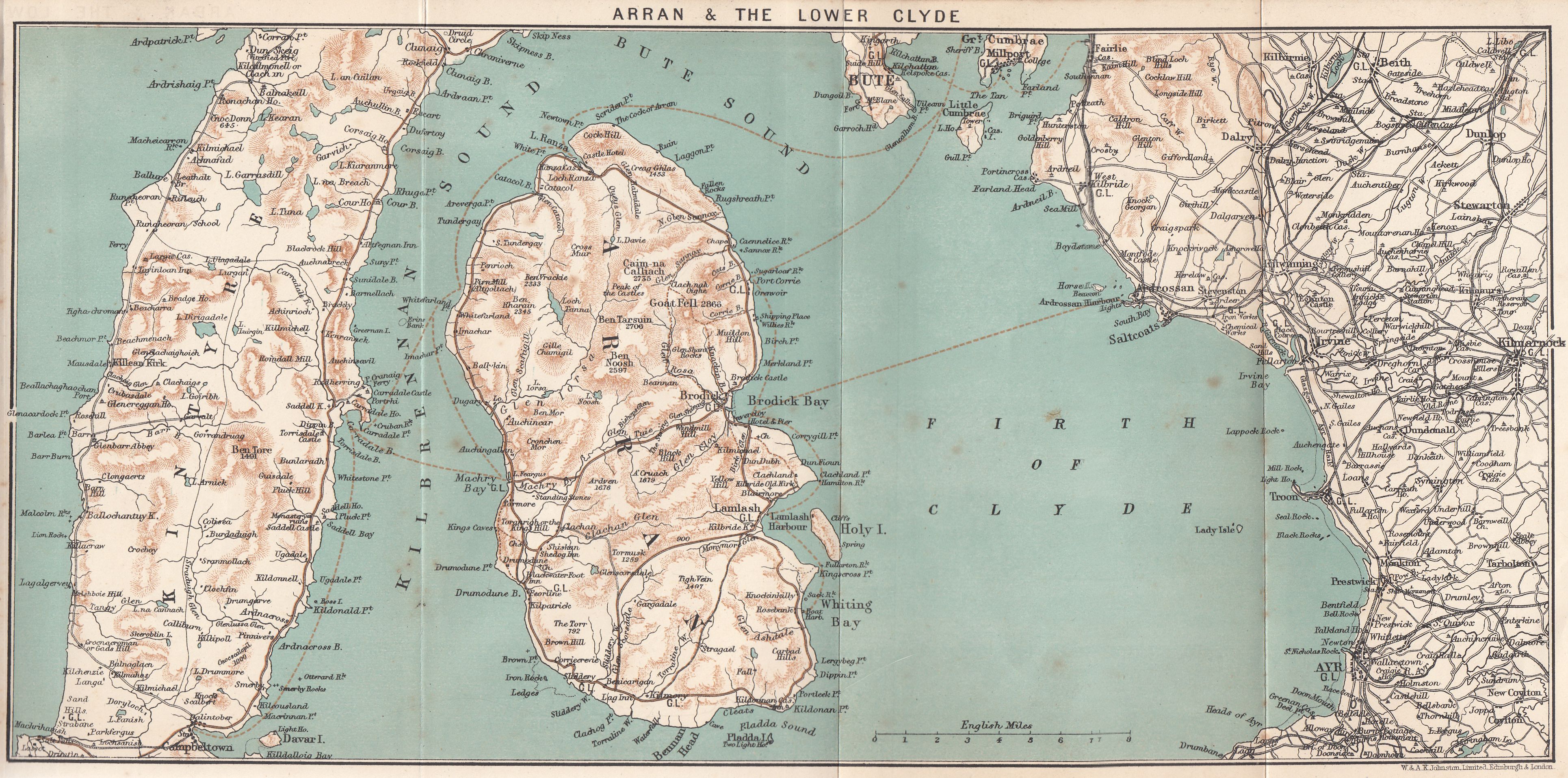
A road leads off (right) to Kildonan Castle, supposed to have been one of a line of forts built by Alexander II. It remained a royal castle till 1405. At Dippen Head, 2 miles farther, there are basaltic columnar rocks rising to 300 feet.
Whiting Bay is a typical little seaside resort, with many new boarding-houses. The hotel, however (terms, 3 guineas per week), is not typical, being a charming range of building looking straight on to the sea, with well-kept flower beds in front. There is also a small temperance hotel (terms, 2 guineas per week). There is a pier here, and as at all the other places numerous charabancs, waggonettes, etc., await the crowded steamboats, the return fares varying from 5s. to £l. The principal excursion at Whiting Bay is the excursion up Glen Easdale (or Ashdale) to the waterfall.
The steep cone of Holy Island forms a natural breakwater to Lamlash Bay. The island rises to 1030 feet, and there is now a lighthouse at each end. There was a monastery on the island, of which the ruins remained until the end of the 16th century. St. Molios, a disciple of St. Columba, made the island his resting-place. His cave is still pointed out, and he is said to have died at Loch Ranza at 120 years of age.
The projecting point of Arran, which comes nearest to the island, is called King's Cross, because Bruce embarked from here for Scotland. A cairn of stones marks the spot.
Lamlash is the largest place on the island. There is a pier, and numerous small hotels, with boarding-houses and lodgings uncountable. It is a pretty place, with the houses set about amid trees and greenery. There is a good golf course of eighteen holes and a good bowling-green. Lamlash is only 3 miles from Brodick Hotel, the road rising over a steep hill and falling again amid fine scenery.
GLASGOW TO ARDRISHAIG via KYLES OF BUTE
See map, p. 360.
There are few persons who have stayed in Glasgow and not indulged in one of the delightful steamer trips by which they can be carried through some of the most beautiful scenery in Scotland. The most popular of all these trips is that through the Kyles of Bute, and many are the facilities offered to intending passengers. The most popular method is to go by one of the larger steamers, Columba or Iona (see p. xi), which sail every day in summer from the Broomielaw at seven o'clock in the morning. This also forms part of the most popular route to Oban, the account of which is continued from Ardrishaig on p. 386. Besides the Columba and Iona there are many other steamers running, notably the turbines (see p. xi), which arrive at Ardrishaig about noon. It is customary for visitors to omit the higher reaches of the river, which, early in the morning, are not attractive, and to join the boat at Greenock or at Gourock, the former from St. Enoch's station (8.20 A.M.) the latter from the Central (8.30 A.M.). But if the return journey be taken, it is well if possible to come right up to the city, especially if it be high tide. And in the light of the westering sun, the scene of magnificent industry is shown to the best advantage.
In going outward we pass first between Govan and Partick; farther on is Whiteinch, with a number of shipbuilding yards.
Renfrew (nine-hole golf course) is not large, but is one of the oldest established towns in Scotland. The great Somerled, Lord of the Isles, who had rebelled against Malcolm II. was here defeated and killed in 1164. Beyond Renfrew is Blythswood House (Lord Blythswood). The collective waters of the two Carts and the Gryfe here flow into the Clyde. The Cart is associated with the name of Thomas Campbell the poet, who played on its banks as a boy and wrote later:-
Scenes of my childhood so dear to my heart,
Ye green waving woods by the margin of Cart.
A large block of stone on the estate marks the place where the 9th Earl of Argyll, a fugitive, in attempting to cross the Cart, was recognised and knocked down by some soldiers. He had refused to subscribe to the Test Act, had been concerned in the Monmouth Rebellion, and after a vain attempt to raise his men, found himself the object of pursuit by soldiers under Atholl and Huntly. He was beheaded at the Market Cross of Edinburgh in 1685.
Directly opposite is Clydebank, a large town in itself, which owes its origin to the shipbuilding works of J. and G. Thomson (now John Brown and Company, Ltd.). The place has a population of over 21,000, almost wholly operatives and workmen at the yards. Between it and Dalmuir are the immense factories of Messrs. Singer (sewing machines) with tall clock tower. Then we pass on the same side Dalmuir, and (near Old Kilpatrick) Erskine Ferry, crossing to Erskine House (Lord Blantyre). From here to Dumbarton a curious wall of stone running between lighthouse towers defines the limits of the navigable river bed. On the right is Dalnottar Hill (753 ft.), from which there is a fine view: the heights immediately to the north are the Kilpatrick Hills, and the village on the narrow plain between them and the river is Old Kilpatrick, said to have been the birthplace of St. Patrick, the tutelary saint of Ireland. All along the pleasant southern bank are palatial mansions built by wealthy Glasgow merchants among the trees. At Bowling the river widens and the Forth and Clyde Canal, which unites the Firths of Forth and Clyde, joins the latter at this place. Dunglass Point is supposed to be the western termination of the Roman Wall of Antoninus, erected in A.D. 140, and locally known as Graham's Dyke (griem diog, the strong trench) and which formed the northern boundary of the kingdom of Strathclyde. On the promontory are Dunglass House and the ruins of Dunglass Castle. The obelisk standing amid the ruins was erected in memory of Henry Bell, who first introduced steam navigation on the Clyde (see p. 299).
Long before this the extraordinary twin lump of rock (240 ft.) which marks Dumbarton must have attracted attention. The rock measures a mile in circumference, and terminates in two peaks, the higher of which is still called "Wallace's Seat," while a part of the castle bears the name of "Wallace's Tower," in commemoration of the Scottish hero, who was confined here. For the castle see below. It may be noted that the true Scottish thistle, which is comparatively rare in Scotland, grows wild on Dumbarton rock.
Dumbarton (Hotel: Elephant; nine-hole golf course) is an uninteresting place, but an important seat of the iron-shipbuilding industry and associate trades, with a population of 20,000. In Church Street are situated the county buildings, and the Dumbarton Academy, with a tower-steeple. In the same street may be seen the remains of an old archway, which, according to an inscription built into an adjoining wall, is "one of the tower arches of St. Patrick's Collegiate Church, founded MCCCCL., and the sole remnant of a once extensive pile, removed to its present site in 1850." Dumbarton owes much to the Denny family (from whom the suburb of Dennystoun takes its name), and to Lord Overtoun, who presented the town with the site of the new municipal buildings at College Park. The Leven flows through the town, and runs into the Clyde near the castle rock. The ground here, 32 acres, at the west of the town, was purchased and presented to the town as a public park by Messrs. Peter Denny and John McMillan. It cost £20,000, and contains fine trees, including two magnificent cedars of Lebanon. Twenty acres are set apart for games. Dumbarton is an important railway junction for Balloch (Loch Lomond) (p. 367), and Helensburgh (p. 414).
Dumbarton Castle is of great antiquity, and is generally supposed to have been the principal seat of the British tribe which inhabited the Vale of Clyde after the departure of the Romans. It was one of the strongholds of the Earl of Lennox, who assumed historical importance so far back as the period of William the Lion.
The adroitness with which Robert Bruce, after he had taken from the English all the other strongholds of Scotland, succeeded in obtaining possession also of the Castle of Dumbarton, is a memorable episode in his life. Sir John Menteith, who was then its keeper, promised to surrender it to him on extravagant conditions, which were agreed upon. His intention in so doing was when Bruce should come to receive possession, to make him a prisoner. For this purpose he had secreted in a cellar a body of armed English soldiers and a ship in the Clyde ready to transport him to London. Bruce, however, was warned of his danger; he, notwithstanding, proceeded to the castle with some attendants, and was welcomed by Menteith, who delivered to him the keys of the castle, and conducted him through it. Bruce observed that he was not admitted into a particular cellar which he passed, and he insisted on its being opened; there the English soldiers were discovered, and they confessed the whole conspiracy. By the order of Bruce, the traitor was himself imprisoned in that very cellar; but he was afterwards pardoned by the generous monarch.
None of the buildings now on the rock are of great architectural interest or antiquity, but some of the foundations and more massive buildings may be very ancient. From the first gate the ascent is by a narrow steep stair, built in a natural fissure of the rock. A narrow gateway here was used as a portcullis, on either side of which may be seen rude well-worn heads of Wallace, and the same John Menteith his betrayer. The latter is represented with his finger in his cheek, which is said to have been the sign to be given by him on this occasion. From the summit there is an extensive view. When Queen Mary was sent to France to be educated at the French Court, she embarked from the castle of Dumbarton for the palace of St. Germain. During the wars which desolated Scotland in her reign, this fortress was taken by an ingenious stratagem by Captain Crawford of Jordanhill.
Taking advantage of a misty and moonless night to bring to the foot of the castle rock the scaling ladders which he had provided, he chose for his terrible experiment the place where the rock was highest, and where, of course, less pains were taken to keep a regular guard. In scaling the second precipice, an accident took place:- One of the party, subject to epileptic fits, was seized by one of these attacks while he was in the act of climbing up the ladder. His illness made it impossible for him either to ascend or descend. To have slain the man would have been a cruel expedient, besides that the fall of his body from the ladder might have alarmed the garrison. Crawford caused him, therefore, to be tied to the ladder, then all the rest descending, they turned the ladder, and thus mounted with ease over the body of the epileptic person. When the party gained the summit they slew the sentinel ere he had time to give the alarm, and easily surprised the slumbering garrison.
A mile below Dumbarton, between that town and Cardross, from which it takes its name, was the castle of Cardross which Bruce made his home in 1326 and where he died June 7, 1329.
From his earliest days he had been in the midst of war, first on the side of the English king and then on behalf of Scotland, and when at last the death of his great enemy Edward I. of England gave him a feeling of security, he showed his domestic tastes in his selection of his home. In the Exchequer Rolls we find such terms as glass for the windows, whitewash for the walls, seed for the garden, and a hedge round the falconhouse, which seem to bring us very near to his simple daily life. His second wife was still alive; by her he had two sons and a daughter. His eldest daughter Marjory, by his first wife, from whom the house of Stewart was to descend, had married Walter the Steward in 1315, and died at the birth of her first child, from the effects of a fall from her horse.
Exactly opposite Dumbarton is Langbank, and then we pass in succession Finlayston House, Broadfield, and Newark Castle, a quadrangular building close to the town of Port-Glasgow: this is now dilapidated, and let out to tenants; part of it is ruinous. Yet it is a pity, for there is much good work in it, and the earlier parts date from the 15th century, the later from the 17th, of the general style of which it is.
From Port-Glasgow a branch line runs to Inverkip and Wemyss Bay, a pleasant and popular coast resort, from which various steamers may be boarded {see pp. xiv and xvi). Skelmorlie with its large hydropathic and old castle, lies to the south: and a couple of miles farther south is Knock Castle, of which parts are said to belong to the 15th century.
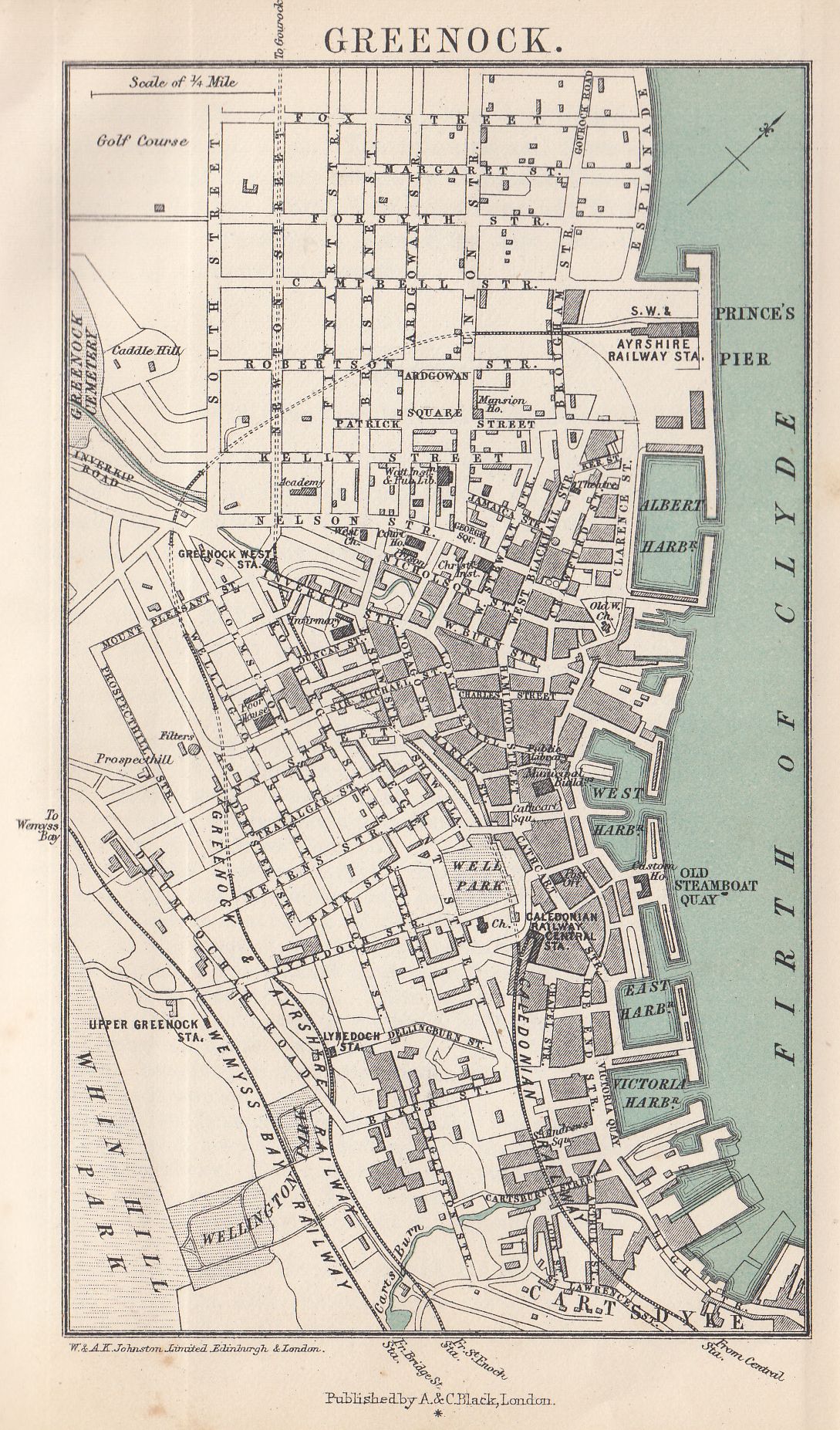
Greenock
Hotel: Tontine. Pop. 68,150.
For sailings of steamers other than those already mentioned see the pink pages in the beginning of the book.
Both the Caledonian and Glasgow and South-Western lines run to the town, but the former arrives at Cathcart Street, and the latter goes right down to the pier. Greenock has a good front, and a pleasant residential quarter as well as a business part, and there is an eighteen-hole golf course. In the beginning of the 17th century it was merely a row of thatched huts, but now has a population of close on 70,000. Shipbuilding, engineering, and sugar refining are its principal industries, and occupy thousands of hands. The docks and harbours are remarkable, and the building yards compete with those of Glasgow; there is a large custom-house on the quay, and in the town are fine municipal buildings, and a public library in the Watt Institution, founded by the son of James Watt to commemorate his father. In the old West Kirk are four fine stained-glass windows designed by William Morris; Burns's Highland Mary is buried in the churchyard. The great sandbank beginning a little below Dumbarton ends near Greenock, and affords the best anchorage in the Clyde. The ocean steamers lying near the "Tail o' the Bank" as it is called, receive here passengers and mails. At the back of the town rises the Whinhill, which commands extensive views; over this a road has been made at great cost.
Gourock (Hotels: Queen's; Ashton; nine-hole golf course), where the steamers next stop, has an unusually fine and spacious pier. The Caledonian railway, which runs down to it, passes through long tunnels in the short distance between Greenock and Gourock; one of these is 1-and-a-quarter miles long - the longest in Scotland. Gourock is not nearly so large a place as Greenock, having a population of between 4000 and 6000 only. It is well situated and commands fine views of the Clyde, including the mouths of the Gareloch, Loch Long, and Holy Loch. Ashton, the more pleasant part, extends from Kempock Point to the Cloch lighthouse. Near the town are Gourock Castle, Gourock House, and Leven Castle (ruin). Craigendoran, Helensburgh, The Gareloch, etc., are mentioned on the West Highland line (p. 414). Ten minutes' sail from Gourock (a distance of about 4 miles) brings us alongside Dunoon pier, where passengers by the North British railway via Craigendoran join the steamer. Passengers from Kirn also join the Columba at Dunoon by connecting steamer.
Dunoon
Hotels: The Argyll (C); MacColl's; Crown.
Steamers ply between Dunoon and Helensburgh. Dunoon is one of the largest watering-places on the Clyde, having a population of close on 7000. Besides the parish church, which occupies a conspicuous position overlooking the pier, there are two Episcopal and several Presbyterian churches. On a queer little conical hill near the pier are the fragments of Dunoon Castle, and near by a very ungraceful statue of Highland Mary.
Villas extend along the coast by Kirn [hotel) and Hunter's Quay (hotel) to Holy Loch, a short arm of the sea, at the head of which are some fine hills. Just above the pier at Hunter's Quay stands the Royal Clyde Yacht Club-house, from which the races are run annually in the Clyde Regatta week. On the north side of Holy Loch is the village of Kilmun (hotel), where there are the ruins of a collegiate church, founded in 1442 by Sir Duncan Campbell of Loch Awe, 1st Lord Campbell and ancestor of the Dukes of Argyll. East of Kilmun is Strone (hotel), a watering-place standing on the point between Holy Loch and Loch Long. On Holy Loch is the village of Sandbank or Ardnadam, with pier and hotel. At the head of the loch is The Cothouse, at one time a favourite inn for anglers. The district stretching from the head of Holy Loch by Loch Eck is a delightful one. There is also a long mountain road due west from Holy Loch, passing the heads of Lochs Striven and Ridden to Otter Ferry on Loch Fyne (22 m.). This begins well, but rapidly roughens, becoming a mere cart track, fit only for pedestrians, before Loch Fyne is reached.
Dunoon to Inveraray. - Pass up the west side of Holy Loch by Sandbank, and keep to the east side of Loch Eck, passing Whistlefield Inn about midway. There are steamers plying on Loch Eck (see p. 398). At the north end of Loch Eck the road descends to Strachur on Loch Fyne, and a steamer may be caught at Creggans Pier (see p. 395).
Leaving Dunoon the steamer skirts the shore to Inellan with a line of shops, and many houses standing, about amid trees. Behind them the hill sweeps upward at a steep angle. There was a particularly large hotel here (the Royal), but it was unfortunately burnt in 1905. Opposite Inellan is Wemyss Bay (see p. 355). The peninsula of Cowal terminates a few miles lower at Toward Point, near which is Castle Toward, and the ruins of an old castle of the Lamont family. The high peaks of Arran may now be well seen to the south.
THE ISLAND OF BUTE
is separated from the mainland by two narrow channels not unlike the Skagerack and Cattegat in shape. These are the famous Kyles. The island is about 16 miles long and averages about 5 miles in breath. It includes several small lochs. The capital is
Rothesay
Hotels: Royal; Bute Arms; Victoria; Queen's (C); Glenburn Hydropathic Establishment, and many others, including several Temperance. Population: 9400.
Rothesay Bay is well known from the popular song of that name, written by Mrs. Craik, author of John Halifax. The bay is certainly very fine, and the line of houses now extends all along it. An esplanade and public gardens line the shore. On the north and south sides the hills, well clothed with trees, rise in the background, and altogether Rothesay is a bright, cheerful place, and in spite of being a little too much "Margatised," it has unrivalled attractions and many advantages. The premier yachting club of Scotland, the Royal Northern, has its headquarters here, and there are two golf courses and two bowling-greens.
Rothesay Castle has existed from very early times, for it was held by the Danes and retaken by Alexander III. after the battle of Largs. In 1398 Robert III. created his son Duke of Rothesay, a title which has ever since been borne by the heir-apparent to the throne. The castle, which stands in ruins, was probably built in the 13th or 14th centuries. It was destroyed by Argyll in 1685. The deep fosse around it was suffered to be choked up by rubbish, but this has now been cleared out and is crossed by a bridge.
About two miles south-west of Rothesay lies the charming little Loch Fad, on the shore of which Edmund Kean built a cottage for himself, this was afterwards tenanted by Sheridan Knowles. About 5 miles from Rothesay is Mount Stuart (Marquess of Bute). Unfortunately the old house was burnt down in 1877, so the present one is quite modern; it is, however, a magnificent place of its kind, and was designed by Dr. R. R. Anderson. A few miles south is Kilchattan, a little sea-bathing place.
Port Bannatyne is now connected with Rothesay by houses all the way, and electric trams pass between the two every few minutes. At Port Bannatyne there is also a large Hydropathic. We pass the Bay of Kames and enter the far-famed Kyles of Bute. On the tongue of land between Lochs Striven and Ridden is South Hall, where the trees were planted to represent the positions of the two armies at the battle of Waterloo, a device common enough at that date.
On the same side is Colintraive, with many villa houses and an hotel. The coach meets the steamer in the summer, and runs up Glendaruel, returning in time for the evening boat. At the head of Loch Ridden is Ormidale, and 6 miles farther on Glendaruel Hotel. It is possible for a pedestrian to get right over to Loch Fyne by this route, striking it at Newton Bay. Near the entrance of the Loch, beyond Colintraive, is Glen Galadh House, belonging to R. Ingham Clark, a well-known yacht owner.
Just about Colintraive the channel of the Kyle is contracted by three or four small islands, which add very greatly to the beauty of the scene. On one of them, by the entrance of Loch Ridden, stands a solitary tree, the scene of the failure of the Earl of Argyll's expedition (see p. 352). On the Bute side are the two remarkable rocks, called The Maids of Bute. Their resemblance to two girls seated side by side, dressed in white with red shawls, is very curious.
All the way the combination of the clear water, the green sloping shores, covered with bracken and diversified by grey rocks, the peeps of distant views up the lochs and ahead, form a series of pictures that can never be forgotten. It is odd that the Government should have chosen this beauty spot as the place wherein to anchor about half a dozen warships, left to fall to pieces of senile decay; but so it is, and a petition to have them removed has not been granted, therefore they remain where they are, a nuisance to hundreds who cruise in these narrow channels for pleasure. The next stop is at Tighnabruaich (pron. Tinnabruach), a word very difficult for southern tongues to pronounce. It means "House of the Brae," because for long there was but one solitary house here, whereas now there is a considerable village with a nine-hole golf course. Hotel: Royal (terms £2:10s. per week (C)). We pass thereafter Kames, where a road (rough) goes across to Loch Fyne, and then we see Ardlamount House, associated with a dark tragedy, situated near the point. To the south is the Island of Inchmarnock, and beyond it rise the towering hills of Arran. We are now in Loch Fyne, and see the long backbone of the Mull of Kintyre stretching away south-westward.
Tarbert
Hotels: Columba (terms, £2:10s, per week); Tarbert; Commercial; Victoria.
Golf course of nine holes.
"Machines" of every variety await the arrival of the steamer. The hotel and various small villa houses are close to the pier, but the village proper is about three-quarters of a mile off, and the fare there is threepence. For conveyance to and from West Loch Tarbert, Campbeltown, see p. 365. Tarbert is a fishing village of the usual type, with numerous small shops, and not a very great amount of charm, but the beautiful islands in the bay, and the bracken-covered hills around, form a delightful situation. High above the houses is the ruin of the old castle. It was rebuilt by King Robert the Bruce when he had finally established himself on the throne, in order to hold in check the turbulent Lord of the Isles. It is now a ruin, part of the keep only remaining.
Tar means I draw, and Bad, a boat, and the name Tarbert is invariably found in connection with some such isthmus of land as there is here. The explanation is that in the old days it was considered necessary to go completely round an island in order to hold it. And this ceremony was performed in the case of the peninsula of Kintyre by Magnus Barefoot of Norway, who allowed himself to be drawn across the isthmus or neck in a galley. It is said that in order to please his subjects King Robert also suffered himself to be drawn across the same place in a boat!
Many times have there been projects to cut through the isthmus by a canal, but there is no reason to suppose the idea will be put into execution.
There is about an hour and forty minutes between the arrival of the Columba at Tarbert and her return from Ardrishaig, and this gives visitors who elect to land time to drive over to the West Loch Tarbert and back (return fare 1s.).
For Jura, Islay, and Kintyre, see below.
There is a rough road running round Knapdale, as the peninsula north of Tarbert is called.
Loch Swen or Swin stretches about 10 miles into Knapdale, nearly opposite Ardrishaig, and its scenery has been pronounced by Dr. McCulloch to be as romantic as that of Loch Katrine. On a rock overhanging the entrance to the loch stand the ancient walls of Castle Swin, whose foundation is ascribed by immemorial tradition to Sweno, Prince of Denmark. The castle - from its position a place of much importance in its day - was taken by Robert the Bruce from Alexander of the Isles, and bestowed on the family of Menteith. It subsequently reverted to the Crown.
In continuing north to Ardrishaig the steamer passes Stonefield and Inverneil, two fine country seats. 10 miles north from Tarbert it enters Loch Gilp, in which stands.
Ardrishaig,
Hotel: The Royal.
the south-eastern terminus of the Crinan Canal, a small village surrounded by several villas which have sprung up since the opening of the canal. The larger town of Lochgilphead (Hotels: Argyll; also Victoria, Stag) stands, as its name implies, at the inner end of Loch Gilp, and on the east side, opposite Ardrishaig, is Kilmory Castle (Sir Arthur J. Campbell-Orde, Bt.). The upper part of Loch Fyne is described at p. 394.
From Ardrishaig it is possible to go (i.) by coach to Ford on Loch Awe and thence by steamer to Loch Awe station (see p. 391); (ii.) or by coach via the Pass of Kilmelfort to Oban (see p. 412); (iii.) for numerous short drives.
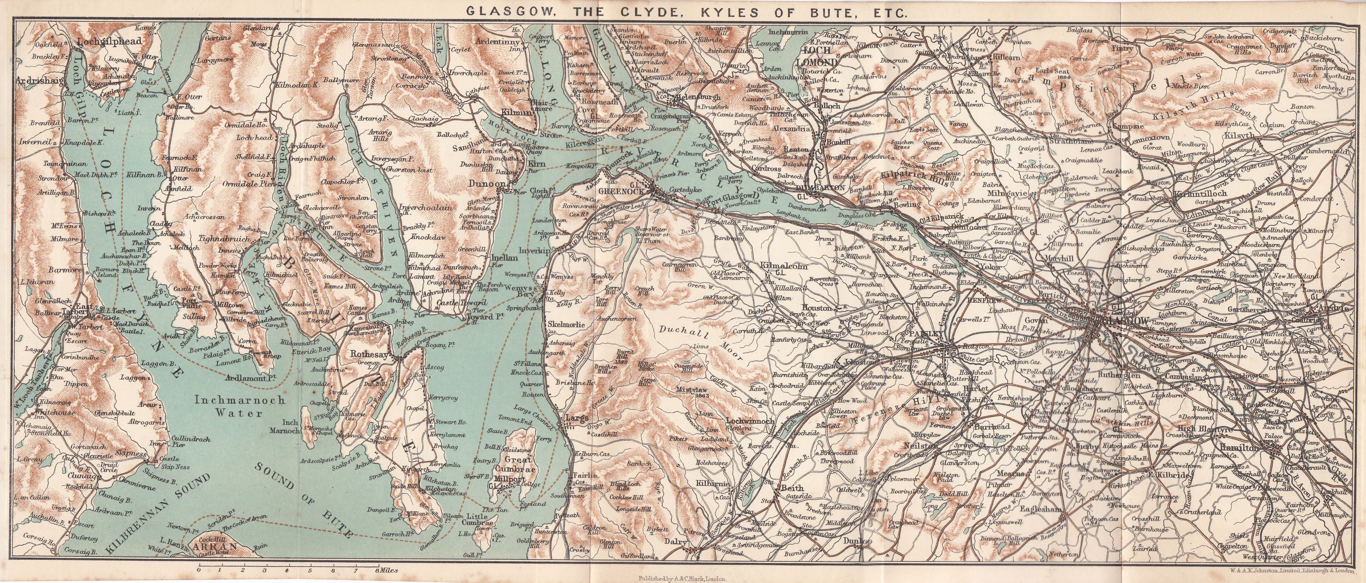
GLASGOW TO ISLAY
See maps, pp. 360, 364.
The route by steamer has been described as far as Tarbert (see p. 352), whence the isthmus must be crossed. There are always numbers of vehicles ready to take passengers across at a very cheap rate, and there is ample time to walk if that method be preferred. Another steamer awaits passengers in West Loch Tarbert, and goes on alternate days to Port Askaig and Port Ellen, crossing the north or south ends of Gigha en route. For Gigha, see p. 365.
ISLAY
It is difficult to liken Islay to anything in shape, so irregular is it. Its extremest length is about 25 miles, and its average breadth cannot be stated, as the great inlet of Loch Indaal bites deeply into it. The island is green like Skye, not brown and barren like the Outer Hebrides. It has some pretty bits, and its hills are sufficiently high to be attractive as features in the landscape. The largest loch, Loch Gorra, is well stocked with excellent trout, and the sport is free. Boats are kept on it by neighbouring farmers and by the hotels at Bruichladdich and Bridgend. In an island on the loch are the remains of one of the Macdonalds' strongholds. Port Askaig has fishing on a couple of little lochs near, but the lochs near Port Ellen are preserved. The roads are like ordinary country roads, quite passable but rough. A large sailing-boat meets the MacBrayne steamer on Tuesdays in the bay to take off goods and passengers for Bowmore and Bruichladdich. Pop. 7780.
Islay belonged to the Lords of the Isles, and the ceremony of anointing the chieftain took place here. He stood on a stone seven feet square and was crowned and anointed in the presence of his warriors, after which they took the oath and swore fealty to him. In the reign of James III. (1415-88) the power of the Lords was abolished, though the family of Macdonald was permitted to hold the island from the Crown. In the time of James VI. it was in the possession of Sir James Macdonald, whose power gave such offence to the King that he sent a force of the McLeans, McLeods, McNeils, and Camerons against him. The laird fled, and in 1620 Islay, with other possessions was granted to Sir John Campbell of Calder.
The three principal landowners of Islay are Hugh Morrison (Islay House), Ian Ramsay (Kildalton), and Donald Martin (Dunlossit).
The principal village is Port Ellen (Hotels: White Hart (C); Islay, Commercial Temp.). There is a very good golf course of eighteen holes at Machry, and the landlords of the various hotels take players free of charge over the intervening 3 miles. As a village Port Ellen is not very attractive, but the surroundings are charming, especially eastward along the coast, where the rocky bays are fringed by rising broken ground covered with bracken and heather. Two or three large distilleries give occupation to many persons. About 5 miles along this road is Kildalton House (Ian Ramsay). Some 3 miles beyond, in the old graveyard, is a famous sculptured cross of great height, of which there is a model in the Glasgow Gallery of Fine Art.
Port Askaig is one of the prettiest places on the island (hotel). Fine trees rise on the heights above the landing-place, and there are only two or three houses. Bridgend (Hotel: terms, £2:10s. per week) is also pretty; near it is Islay House (Hugh Morrison). Bowmore is a fishing village with the usual rather rough accompaniments. Beyond these there are no other places to mention.
JURA
Jura is separated from Islay by the Sound of Islay, a narrow strait (through which the tides flow with great force), only half a mile broad at the picturesque fishing station of Port Askaig in Islay, where there is a ferry. Like the Mull of Kintyre, it is nearly cut in two at the centre by a loch of the same name, Tarbert, the neck of land being only three-quarters of a mile in breadth. It is 27 miles long, and, excepting in the centre, from 3 to 8 broad; and has a population of about 600. The southern and larger portion belongs to Campbell of Jura, whose mansion (Jura House) stands at the extreme south. The great charm of the island to those who love solitude is its lack of roads: one road only runs along part of the east coast, and any one who wants to see farther must go afoot. The hills are much grander than those of Islay. The Paps of Jura, two mountains in the centre of the lower division of the island, are conspicuous objects, and rise to the height of about 2500 feet, and the whole scenery of the island is wild and rugged, and interspersed with numerous small rocks. The greater part is deer-forest. There are inns at Lagg and Craighouse, both on the east coast; and there is a ferry from the former to Keills on the mainland at Loch Swen.
COLONSAY AND ORONSAY
Westward of Jura lie the lonely islands of Colonsay and Oronsay. The former is about 8 miles long; and the two together have a population of about 300. At its north-west shores are some magnificent cliffs, one spot-known as the "Pigs' Paradise" - being unique in its strange beauty, though rather difficult of access. At various points round the coast are sandy beaches - Killoran Bay being perhaps the finest. In the neighbourhood are some extensive caves. Oronsay Priory or Colonsay House (Major A. J. McNeill) is pleasantly situated south of this bay, and is approached by a high road from Scalasaig (pier and inn) on the east coast. Near Scalasaig is a granite obelisk in memory of Lord Colonsay, a distinguished Scotch lawyer who died in 1874. On the west coast, opposite Scalasaig, lies Kilchattan Bay, where there is an extensive golf course, naturally good, but said to suffer somewhat from want of attention.
Close to the south end of Colonsay, and separated from it by a quite narrow sandy strait, fordable at low water, is Oronsay, on which are the ruins of an ancient monastery, and a remarkably fine early Christian Cross.
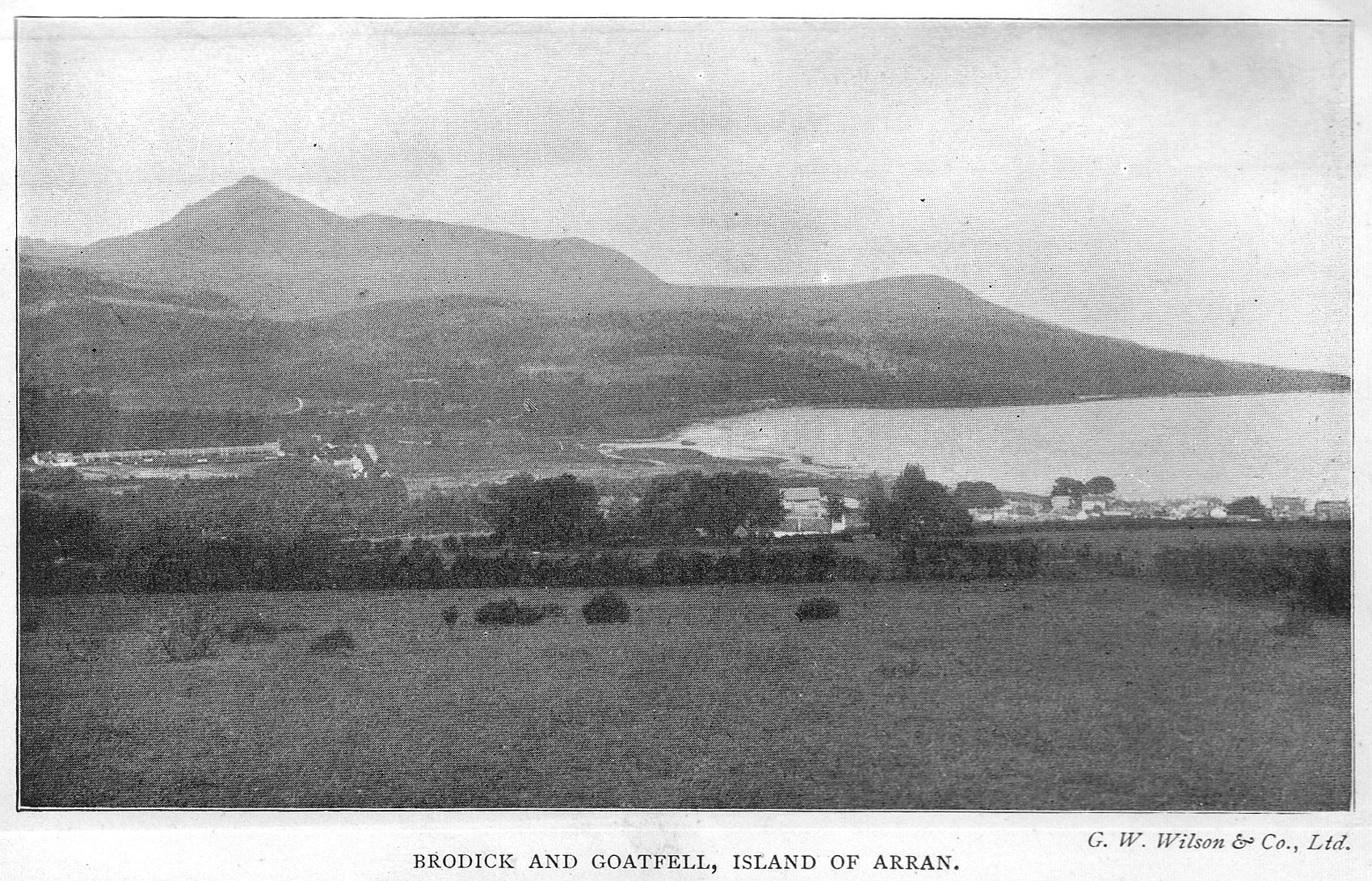
THE MULL OF KINTYRE
See maps, PP. 350, 364.
Glasgow to Tarbert, see steamer route, p. 352. For coaches see p. iv.
This long and curious peninsula must always have formed a great obstacle to those who wished to pass quickly about on these seas. It is 40 miles long, with an average breadth of 7 miles, and is traversed by a long backbone of heathery hills sloping to the sea on each side.
On leaving Tarbert we cross the narrow neck of land, with the ruins of the castle above, and come out on the shores of West Loch Tarbert, where the little steamer is making ready to go to Islay. The total distance between Campbeltown and Tarbert is 38 miles (coach fare 10s.), and the road on the west coast is mainly level or undulating with one or two hills, to be noted on the way. The road on the east coast is extremely hilly, and the surface not so good. At about 6 miles from Tarbert, just, before Whitehouse, a road goes off east and crosses the peninsula to the other side. 2 miles from the point of intersection is Skipness, a small fishing hamlet with the ruins of an old castle. It must have been at one time a place of considerable strength, but there is no history recorded of it, though its origin is attributed to the Danes.
At Whitehouse there is a post-office. From here the main road rises steeply, and with a short down hill mounts again over 400 feet, before falling to Clachan, where are Ballinakill House and Dunsheig Bay. After this the way is level through Ballochroy to Tayinloan, and the green island of Gigha is seen very clearly a few miles from the shore. Gigha (pron. Ghee-a) is about 6 miles by 2 in length and breadth. Inn at Ardminish. Though the island looks so low-lying and green, its coasts are rocky, and there are several remarkable caves in it.
At Tayinloan we are just half-way to Campbeltown, and with the exception of a hill near Glenbarn, there is nothing to remark upon for the next 15 miles; then the road turns inland by Kilkenzie, leaving on the right the famous golf course of Machrihanish (Hotel: Ugadale Arms, large, modern), one of the best known in the kingdom. The course is eighteen holes and the length somewhat under 3-and-a-half miles. There is also a ladies' links. Conveyances run between Machrihanish and Campbeltown (return fare Is. 6d.), and besides the hotel at Machrihanish there is quite a colony of houses, at the south end of the bay. At one time the place was famous for its saltpans, a name by which it is still known locally.
Campbeltown
Hotels: White Hart; Argyll Arms; Alma (C).
Campbeltown can be reached direct by steamer (see p. xiv) as well as via Tarbert. It is the chief town in Argyllshire (pop. 8286), and is a fairly busy place, being the greatest whisky distilling centre in the United Kingdom, having no less than twenty distilleries. It is also the head of the fishing district between Fort William and Inveraray, carries on shipbuilding, and publishes two weekly newspapers, the Argyllshire Herald, and Campbeltown Courier. The town is spread over a large area, and divided into three districts, the town proper, Lochend, and Dalintober. The principal street is Main Street, where there are the two hotels and post-office. Midway up Main Street is a fine Celtic Cross, one of the most famous of its kind, richly carved.
Two other prominent buildings in the town are the U.F. Church in the Graeco-Italian style with a massive tower and lantern dome, and the Public Library and Museum opened in 1899. The Library contains the records of the Challenger expedition in a set of forty-eight volumes.
History: The place is said to be the site of a cell of St. Kiara, the patron saint of the district. The name became Kilkerran, and the Lords of the Isles made it one of their principal strongholds, rechristening it Kinlochkerran. When the clans were sent by the king to dispossess Macdonald, in the reign of James V., they attacked and destroyed Kilkerran, and it was afterwards granted, with the rest of the neighbourhood, to the Campbells. In 1700, under the name of Campbeltown, it was constituted a royal burgh.
The deeply-indented loch, at the head of which the town stands, is still farther protected by the island of Davaar, where there is a lighthouse, and a mural painting (modern) of Our Lord on the Cross; this is in a cave in a very striking position and worth seeing. The idea originated in a dream of the artist's.
Campbeltown is not at the extremity of Kintyre, which bulges out beyond it into the well-known headland called the Mull. A road runs across southward through Conie Glen to Southend (eighteen-hole golf course), overlooking the island of Sanda. Not far from Southend is Dunaverty, "The Rock of Blood," where once stood a stronghold of the Lords of the Isles, where Angus, then chief, entertained Bruce in 1306. In the 17th century General Leslie, of the Covenanters' army, besieged and took it, and killed the garrison of 300 men; not a vestige of the castle now remains. The Mull stands up boldly and grandly; it is only 13 miles from Ireland.
About 10 miles from Campbeltown, north, is Saddell, in a deep valley. The rains of an ancient abbey here are picturesque as well as interesting. The abbey was founded about the end of the 12th century for Cistercian monks; not far off is the tower of Saddell Castle, with the modern house close to it. In spite of the hills to be surmounted, this little place is one worthy of a visit. A few miles farther on is Torrisdale Bay and Castle, and then the well-sheltered Bay of Carradale with its village and pier; near it is Saddell Church with some old sculptured stones in the churchyard; also Carradale House.
GLASGOW TO CALLANDER through the Trossachs.
See maps, pp. 374, 394.
One can go by either the Caledonian or North British railways to Balloch at the south end of Loch Lomond, both lines starting from the low level of the respective stations, or cycle by the road to Dumbarton, and thence northward. As far as Dumbarton, see p. 352. About 2 miles north of that place both road and rail pass through the village of Renton, which contains an obelisk to the memory of Tobias Smollett the novelist, who was born in the neighbourhood at Dalquhurn, Cardross, in 1721.
It will be remembered that his father was the youngest son of Sir James Smollett of Bonhill House and had made an imprudent match. Tobias cherished resentful memories of his grandfather, whose harshness he has greatly exaggerated in the partly autobiographical tale of Roderick Random.
The villages of Bonhill and Alexandria are very busy with bleaching and printing works, in which the chief source of power is the river Leven. Smollett; whose recollections of the place of his childhood were very vivid, has left on record of the Leven the lines:-
Pure stream, in whose transparent wave
My youthful limbs I used to lave.
It need hardly be said that it would take a bold person to wash in the stream as it is at present! Shortly before Balloch Tulliechewan Castle (modern), the seat of W. McO. Campbell, is passed. Balloch (Hotels: Balloch; Tulliechewan (C. and temp.)). The train runs straight on to the pier where the steamer is waiting.
LOCH LOMOND
Loch Lomond is the best known of all the Scottish lochs, and though it is 3 miles shorter than Loch Awe, and lacks the romance thrown over Loch Katrine by Scott's genius, it is beautiful and varied enough to charm the most jaded taste. Its proximity to Glasgow enables hundreds to pour on to its shores, and fill its steamers every holiday; but this, though certainly detracting from its delights to a lover of nature, also proves a source of joy and of education to multitudes who would not otherwise have opportunities for seeing natural beauty. The loch was anciently known as Loch Leven, from the stream that flows out at its southern extremity, but the name Lomond seems to have been used contemporaneously in various forms, and is very ancient.
At its southern end the loch is about 5 miles in width and bears on its surface a perfect archipelago of islands, once thickly populated, now mostly left to deer and other wild creatures. There is a tradition of a floating island repeated by many an ancient traveller, but all trace of this phenomenon has disappeared. The waters of the loch contain salmon, sea-trout, lake-trout, pike, and perch, and the fishing is free: as, however, the charge for a boat is usually 2s. a day and for a man 5s., the sport is not inexpensive. One of the best roads in Scotland for cyclists runs the whole length of the loch on the west, but for the first few miles this is cut off from views of the water by the walls and grounds of private houses, which is a drawback. Steamers run thrice daily each day and touch Balmaha, Luss, Rowardennan, Tarbet, Inversnaid, and Ardlui, thus crossing from one side to the other and affording every opportunity for a varied prospect.
On leaving the pier, Balloch and Boturich Castles are seen on the right, and left is the entrance to Glenfruin, " The Glen of Sorrow," to which a terrible history is attached.
The Macgregors, outlaws among the clans, whose hands were against every man, had come down in force against the Colquhouns of Luss. A terrible fight ensued, sanguinary even in the days of broadsword and hand-to-hand ferocity. In this the Macgregors were completely victorious, but the contest was marked by a deplorable event, for a number of youths of good family happened to be with their tutor near the scene of the battle and were hurried for safety into a barn. These were put under the charge of a Macgregor, who, misunderstanding his instructions, murdered them all - a deed which brought savage vengeance on his clan.
Proudly our pibroch has thrill'd in Glen Fruin,
And Bannochar's groans to our slogan replied;
Glen Luss and Rossdhu, they are smoking in ruin,
And the best of Loch Lomond lie dead on her side.
Lady of the Lake.
Overlooking Glen Fruin are the ruins of the castle of Bannachra, once the residence of the Colquhouns, the chief of which clan was slain here by a Macfarlane in 1592. Nearer the water is the splendid modern mansion of Arden (James Lumsden). Farther north, just where the Helensburgh road comes in (see p. 414), is the wooded promontory of Rossdhu, seat of the Colquhouns (pron. Cohoon) of Luss.
Sir A. J. Colquhoun, the present head of the family, represents two of the most ancient lines in the country, being able to trace back his ancestors on the Colquhoun side to 1190, and those on the Luss side to 1150. In or about 1368 the two families were united by the marriage of Robert Colquhoun with the heiress of Luss.
The old castle of Rossdhu was at one time the chief residence of the Colquhouns, and a fragment of its walls still stands upon the headland of that name. About the end of the 18th century a new mansion was built, which has since been greatly enlarged. Not far off are the Court Hill and Gallows Hill, where the chieftain executed justice and punishment. The slogan of the clan means "Knoll of the Willow," a tree which still grows in the district. But while the Colquhouns occupied the south end of the loch, the "wild Macfarlane's plaided clan" held the northern.
The steamer keeps at first to the eastern side of the loch and goes between the mainland and the large island of Inchmurrin, preserved as a deer-park. At the south end are the ruins of a castle, once a residence of the Earls of Lennox. Here Isabel, Duchess of Albany, retired when all her menkind, father, husband, and sons, had been executed at Stirling in 1424. On the mainland is Ross Priory (Sir Alexander Leith-Buchanan, Bt.), where Scott wrote part of Rob Roy, and Buchanan Castle (Duke of Montrose) lies farther northward, the grounds being bounded by the Endrick water, We then pass two tiny islets and go between Clairinch, from which the Buchanans took their slogan, and Inch Caillach, which means the "Island of Women," so called from its being the site of a nunnery. There are the ruins of a church upon it, and an old burial-ground of the Macgregors.
The steamer touches at Balmaha pier, which is at the foot of Conic Hill (1175 ft.). The pass of Balmaha was one of the best known of many roads by which the wild Highlanders descended to raid the Lowlanders in the old stormy days. Then we cross over to Luss, passing Inchfad (Long Island), Inchcruin (Round Island), and between Inchlonaig (Isle of Yew-trees), well named, and now a deer-park, and Inchconnachan. On the other side of Inchconnachan is Inch Tavannach (Monk's Island). To the south is Rossdhu, already mentioned. Luss (hotel) stands at the foot of Glen Luss, which rises steeply into high hills. The archipelago is soon left behind, the shores of the loch narrow, and the scenery becomes bolder as we approach Rowardennan (hotel) on the eastern shore. The ascent of Ben Lomond (3192 ft.) is generally made from here. Though it may also be made from Inversnaid, where the distance is greater.
The ascent from Rowardennan to the top is about 3-and-a-half miles, and is not very stiff considering the rise. Ponies may be hired at a charge of 10s. each. The scene from the summit is very extensive on a clear day, including the chain of the Grampians, and on the west the Argyllshire hills, while south and east is the fertile lowland district. The counties of Renfrew, Lanark, and Ayr, the Firth of Clyde, and the islands of Bute and Arran may be seen to the south. Stirlingshire and the Lothians, with the windings of the Forth to the east, and many points of interest may be made out in detail by those with good eyesight.
There is a ferry (6d.) over the loch from Rowardennan to Inverbeg, at the foot of Glen Douglas, where there is an inn, and the loch at this point is not more than a mile across. Skirting the base of Ben Lomond a great cavern in the cliffs is pointed out as Rob Roy's Prison. Then we reach Tarbet (hotel) on the west side, where the railway turns down to the loch. There is here a very large hotel, no boarding terms in the season, prices the same as at Inversnaid and Stronachlachar.
The name Tarbet, as has been stated in another place, means draw-boat, and the story goes that Haco, King of Norway, in 1263 entered Loch Long, and sailing to the head made his men drag the high-prowed boats over the narrow neck of land at this place and launch them on Loch Lomond, after which he killed and plundered the people living on the islands.
Tarbet was for long the headquarters of the Macfarlanes, who were the chieftains of the northern part of the loch for many generations. The Earl of Lennox came from this clan, who were almost as renowned as the Macgregors for their desperate deeds (see p. 381). They were hostile to the clan of Lorn, and as the Lorn country was so near there were perpetual raids and recriminations. Their earliest residence was on the isle of Inveruglas, and later, when that fortress was destroyed, on an outer islet about 2-and-a-half miles above Inveruglas (see below). When they settled on the mainland, it was at Tarbet, after which they moved to Arrochar House, which was known as New Tarbet for some time.
The Inveruglas Water runs down from Loch Sloy, securely hemmed in by mighty hills, among which towers Ben Voirlich (3092 ft.). From Tarbet the steamer crosses to Inversnaid, where those bound for the Trossachs disembark. As for the remaining distance to the head of the loch there is not much to comment on. The Island Vow still retains some fragments of the Macfarlanes' stronghold. This name is a corruption of Eilan Vhow, meaning "The Brownie's Isle," and is referred to in Wordsworth's "The Brownie." A little farther on, near the railway, there is a curious rock called the Pulpit Rock, with a cell cut in its face so that it could be used for open-air preaching, and at the head of the loch is Ardlui (see p. 415). Not a mile from Inversnaid, on the same shore, is Rob Roy's Cavern, for many are the associations of the wild chief with this district. Rob's own designation was of Inversnaid, but about 1712, probably in consequence of some bolder act of depredation than usual, he found it advisable to remove his headquarters farther into the mountains.
At Inversnaid is a large modern comfortable hotel, terms per tariff in season. It is impossible not to reflect here on the difference of scene since the time when Wordsworth and his sister made their tour in 1803; then they were thankful to be received into a rough shieling and get porridge to eat. It was a girl he saw here who suggested to Wordsworth his poem "To a Highland Girl." There is a splendid fall of water, as the Arklet leaps to the loch, in the hotel grounds, a stone's throw from the windows, and a charming walk up by the wooded banks of the foaming water for a mile or more. Many of the wanderings of a more important man than Rob Roy took place in this district, for Robert Bruce was often hunted among the woods from one refuge to another, and at last with difficulty escaped the dangerous neighbourhood of his bitter enemies the men of Lorn.
Coaches meet the steamers in the summer, running backwards and forwards five and six times daily between Inversnaid and Stronachlachar on Loch Katrine. The beginning of the way is a very steep ascent indeed, which continues for long, and thereafter the whole distance to the point where the Loch Ard road joins it is a continual rise, though less severe than at first. Distance 5 miles and surface bad to fair. About 1 mile from Inversnaid are passed the remains of the fort built by King William to overawe the rebels. There is nothing now to suggest a building, only a few earthworks remain. On the route is passed Loch Arklet, which lies too flat between its shores to be very pretty, but nevertheless the scenery is attractive with open moorland and rising hills. At the north end is Corriearklet, a favourite residence of Rob and his wife Helen. At less than a mile from Stronachlachar a road goes to Loch Ard and Aberfoyle (see p. 343 reverse way), and we drop down to Stronachlachar (hotel), near which the roads are unspeakable after rain. The pier is in the hotel grounds, and the hotel itself one of the same kind as at Inversnaid, where every comfort can be had by paying for it. Post and telegraph office in hotel.
At the risk of being wearisome, one cannot refrain from returning again to Dorothy Wordsworth and her brother as they stood on the shores of this windy inhospitable spot - no hotel then - and wondered how in the world they were to get on to Callander; great mirth they provoked amid the haymakers whom they found at last in a field near the head of the loch, when they said they had come to see the Trossachs. Little did those simple-minded country folk guess the time ahead when a constant stream of rich tourists should pour through their wild district on that same quest.
LOCH KATRINE
Scott suggests that this name arose from the hordes of caterans or robbers who made the wooded banks and surrounding hills their eyries from which to descend and rob the Lowlander; but this derivation cannot be seriously accepted. The loch is 8 miles long, and has an average breadth of about three-quarters of a mile, but its sinuous shape and the deep indentations of its shores make it appear larger. The steamboat makes several trips daily between Stronachlachar and the Trossachs, and there is no continuous road by either side, those who want to go through direct to Callander must use the steamer (fare. 2s. 6d.). A road runs for part of the way along the north side and then degenerates into a foot-track, which might be used for a light conveyance, but is quite unsuitable for cycles. The loch belongs to the Duke of Montrose, the Earl of Ancaster,and Mrs. MacGregor of Glengyle. It contains good trout, char, and pike, and can be fished by visitors at the Stronachlachar and Trossachs hotels, with a charge of 5s. per day for boat and boatman. Glengyle was the birthplace of Rob Roy. Scott's Lady of the Lake has added glamour and romance to this beautiful loch, and no one who goes there should fail to read that poem, and also the very clever explanation of its topography by Sir G. B. Airy in our smaller guide to The Trossachs.
One burnished sheet of living gold,
Loch Katrine lay beneath him rolled,
In all her length far winding lay,
With promontory, creek, and bay,
And islands that, empurpled bright
Floated amid the livelier light,
And mountains, that like giants stand,
To sentinel enchanted land.
SCOTT.
The full beauties of the loch are at the east end, where Ben Venue, in mighty purple folds, rises from the water's edge, and the foreground is occupied by the thickly-wooded shores of Ellen's Isle.
The name of the island has given rise to several theories, but it probably arose from Scott's unperfectly grasping the word Eilean, which merely means an island. One account says that the Highlanders used the island as a refuge from the ferocity of Cromwell's soldiers, one of whom swam across to it, but was beheaded by Helen Stuart before he could gain firm footing; and it is suggested that from this "Helen" the name originated.
High up in the hills, to the west of Ben Venue, is a tiny loch called the Tinker's Loch, in which are many small trout. Nearly opposite Ellen's Isle lies the famous Silver Strand, nearly hidden now that the Glasgow waterworks have raised the level of the water, and beyond it was the huge promontory which barred the way to Fitz-James, but which has been blown partly away to make room for the road. Every one who has time should walk along this road on alighting from the steamer, and continue some distance until they get a fine view of Ben Venue.
High to the south, huge Ben Venue
Down to the lake in masses threw
Crags, knolls, and mounds, confusedly hurled,
The fragments of an earlier world,
SCOTT.
which is a very good account of his bewildering mystery of outline. This great mountain has two peaks rising respectively to 2393 and 2386 feet, and only separated by a quarter of a mile. Opposite is Ben A'an, only 1750 feet. On the south side of Loch Katrine is the station of the Glasgow waterworks, opened by Queen Victoria in 1859.
There are one or two ways of ascending Ben Venue, but, as in many other cases, the view from the summit is not extensive owing to the great bulk of the mountain itself. The ascent may be made by the Pass of Bealach-nambo, the "Pass of the Cattle," which is reached by the path to the sluices. By this route one circles half round the great hill and makes the ascent from the north. It may also be approached by the Pass of Achray.
The Goblin's Cave mentioned by Scott is impossible of identification, for
The dell upon the mountain's crest
Yawned like a gash on warrior's breast,
evidently refers to Bealach-nambo.
Rates charged for boats on the loch are 1s. 6d., 2s. 6d., and 3s. 6d. for 1, 2, and 3 hours respectively (without boatman); or 5s. for the whole day. Over four persons, 6d. extra per hour.
A coach meets the steamer to take passengers to the Trossachs Hotel and Callander. The road at first is of exquisite loveliness, lying right through the richly-wooded ground of the Trossachs, which name signifies "bristled territory." Sir Walter Scott speaks of "Trossachs shaggy glen," which is about as good a short description as could be given. Near the head of Loch Achray is the road to Aberfoyle (see p. 375). The Trossachs Hotel belongs to the same proprietor as the hotel at Inversnaid, terms as on p. 375. The palatial building is splendidly situated; in it there is a post and telegraph office. Loch Achray affords good sport to visitors, and boats are kept for their use. The fishing is free.
Environs and Excursions.
The ascent of Ben A'an is not stiff, and is easily accomplished from the hotel. It is begun by going up from the laundry at the back of the building and turning to the left after the first rocky height is gained, and almost due north-westward in continuation. There is also a pleasant foot-track round Loch Achray. For those who like long mountain walks there are many to be reached from Glenfinlas. On leaving the hotel follow the Callander road for about a mile and a half to the Brig o' Turk, then turn left till Achnahard Farm is reached. About a half mile from the main road a series of cascades will be seen, and above the stream rises the rock called "The Hero's Targe" in The Lady of the Lake, canto iv. From the farm the ascent of Ben Ledi (2875 ft.) may be made, or crossing the stream one may continue straight ahead northward over high ground and descend into Glen Buckie, thence road to Balquhidder, or turning (right) over the shoulder of a hill drop down on the charming little village of Strathyre (see p. 379); total distance from Achnahard 7 miles.
Trossachs to Aberfoyle (6m.)
A toll of sixpence apiece, a ridiculous impost, is here demanded from cyclists; for horse vehicles, 1s. 6d. and upwards, nominally for the expenses of making up the road, which must have been paid over and over again.
The road breaks off from the Trossachs at the head of Loch Achray, and following the loch round for a short time climbs up a beautiful valley with heathery moors on all sides and splendid views of the hills, including the Trossachs, backed by distant Ben More and the mass of Ben Ledi on the north. Near the summit is a wonderful peep of Loch Drunkie, lying deep in a cleft; not far off is the clear well known as Rob Roy's Well, and then with great steepness the road falls, leaving on the right the slate quarries of Aberfoyle, and descends to Aberfoyle itself. Many people take this route in preference to continuing by Callander, and catch a North British train at Aberfoyle; for Aberfoyle and district, see p. 341.
Continuing now from the Trossachs Hotel on the main route to Callander, we pass by an excellent bit of road along the shores of Loch Achray to Brig o' Turk, where "the headmost horseman rode alone." Here there is a little hamlet, where lodgings of a simple kind can be found. From here southward a track goes to Loch Drunkie (preserved) and along by Loch Vennachar. After Brig o' Turk is Lanrick Mead (right), the mustering-place of Clan Alpine (Macgregors). The road rapidly worsens, and for the rest of the way to Callander is a disgrace to the neighbourhood. Motor cars are forbidden; perhaps because of its narrowness, perhaps because those who are responsible fear that an outcry would be raised against them for allowing this much-frequented road to welter in mud and dust. Loch Vennachar, in spite of its high-sounding name, and Sir Walter's
Here Vennachar in silver flows,
There ridge on ridge Ben Ledi rose,
is distinctly disappointing. In fact, having reached Brig o' Turk, the traveller has seen far the best part of the trip. At the end of the loch can be seen the somewhat fanciful erections at the sluices connected with the waterworks. These are at the old Coilantogle Ford, the scene of the fight between the disguised king and Roderick Dhu, so spiritedly told in the Lady of the Lake. Fishing is free, but the charge for a boatman 5s. a day; trout, pike, and perch are caught here. The slopes of Ben Ledi (2875 ft.) rise on the north - the name means the Mount of God, and is supposed to have originated in the Beltane mysteries celebrated on it. Then the large Hydropathic comes into view, amid trees on the south, and the road passes over the railway line and the river Leny, by Kilmahog Bridge, and joins the main road north, in which we turn sharply (right) for Callander.
CALLANDER
Hotels: Dreadnought Arms (C); Ancaster Arms; Hydropathic; and four or more Temperance. Pop. 1500.
The Dreadnought Arms, which stands close to the station, is quite the best hotel in the town (terms, 12s. per day), and is very comfortable and not pretentious. At the temperance hotels, which are small, one can find board at the reasonable charge of about two guineas per week. The Hydropathic is one of those immense buildings so popular in Scotland, where the amusement of the guests forms a principal consideration.
Callander itself stands in the valley of the Teith, and is rather relaxing, but the surroundings are beautiful. It has grown of late years more and more popular with holiday guests, who find in its unspoiled simplicity and surroundings much that is attractive. Coaches run in all directions, many times daily in the season, the principal route being, of course, that across the Trossachs.
Environs. - The favourite place for a stroll in the immediate neighbourhood is the Falls of Bracklinn, about 2 miles north-east. They are on the Keltie Water, and the walk to them is pleasant, and commands fine views as it rises higher and higher. One may pass to the east, either down the main street or the parallel road above, and turn left at the end, whence the way cannot be missed. A rustic bridge has been thrown over the chasm, down which the water dashes itself with force from a height of 50 feet. By the same track, instead of turning down to the Falls, good walkers may go on up the Keltie valley to where the road ends at Luirgeann, and thence by a foot-track right over to Glenartney, or straight on, passing near the summit of Ben Voirlich, by a tremendous walk to Loch Earn, near Ardvorlich.
The route from Callander northward has been described as part of the Callander and Oban line (see p. 378).
Callander to Dunblane and Stirling
There is a Roman camp shortly after leaving Callander, then road and rail both cross the Keltie Water, which, not much farther down, joins the Teith. There are roads on both sides of the Teith, equally good, and roads, rail, and river run together in the valley past Lanrick Castle (Sir Robert Jardine, Bt.) to Doune. 3 miles from Lanrick is Cambusmore, where Sir Walter Scott passed several summers as a boy. Adjoining Cambusmore is Sart, the Highland resort of the famous Lord John Russell.
Doune (Hotels: Woodside, Temperance (C)). - A quaint and pleasant little place, with a fine bridge, gifted by Robert Spittel, tailor to James IV.'s queen, as an inscription tells us, beside which he has boldly cut a pair of scissors as his crest. About half a mile below the bridge, on a peninsula formed by the junction of the Ardoch and the Teith, stands the old Castle of Doune, still a majestic pile, with its two massive square towers, turrets, and high battlemented walls.
The modern house, Doune Lodge (Earl of Moray), stands about a mile away, and the owner spent a large amount of money on putting the castle into good repair. It is now open to visitors on payment of a small fee to the caretaker.
Doune belonged to Murdoch, Duke of Albany, who governed the country while the young King James I. was still prisoner in England, and who probably built the castle. His overweening ambition made him an early mark for the vengeance of the king on his return, and he was executed at Stirling within sight of his own castle turrets, while his lands and residence were forfeited to the king. Several queens of Scotland, including Queen Mary, are said to have used the castle as a royal residence. It is mentioned in Waverley; and it was for some time the only fortress held by the Jacobites in Scotland. John Home the poet, author of Douglas, was taken prisoner at the battle of Falkirk, and with five comrades imprisoned here, but they found means to escape after a time-honoured recipe by twisting their bedclothes into ropes and dropping from the windows.
Due south of Doune is Blair Drummond (Lieut.-Col. H. E. Stirling- Home-Drummond); also Deanston House and mills.
From Doune to Aberfoyle and the Menteith district, see p. 342.
On leaving Doune the line travels due eastward to Dunblane. Between the two places it crosses Ardoch Burn, which gives its name to the famous camp (see Scotland, B.C., p. 110).
Dunblane (Hotels: Stirling Arms- (C); Hydropathic (see Scotland, E.C., p. 111)). - Here comes in the line from Perth by the side of the Allan Water, which has already been fully described.
Between Dunblane and Stirling are six miles (see Scotland, S.E.), in which we pass Bridge of Allan.